
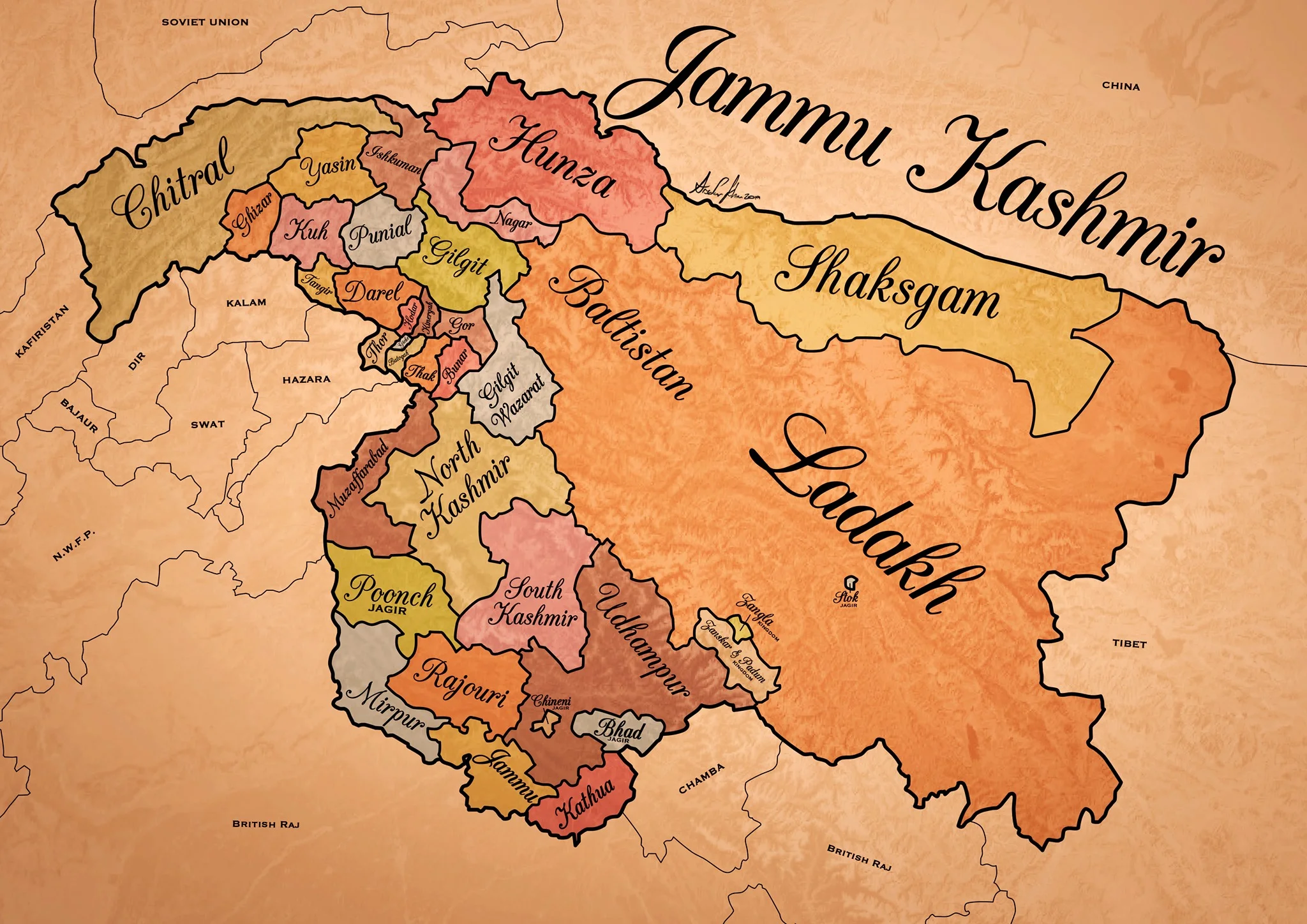
Historical Map of the Dogra Kingdom of Jammu and Kashmir
The State of Jammu and Kashmir as it was at its largest extent under the rule of the Dogras. This Map helps people understand the complicated Geography and Diversity of the erstwhile State of Jammu and Kashmir.

Historical Map of the Dogra Kingdom of Jammu and Kashmir
Another interesting Map of the previously E Jammu Kashmir by my talented friend Arsalan Khan who also belongs to the Riyasat. We had previously had an Article on the various Indigenous People of Jammu and Kashmir. Its not perfect, has its anomalies but it still an indicator of the diversity of the State from a Political angle. This Map shows the Dogra Kingdom at its most expansive. And i would like to point out that all these different areas were won over by the Dogras / Dogras under the Sikhs in War except Kashmir which was granted as a part of the Treaty between the British and Raja Gulab Singh on the payment of War Indemnity of 75 lakhs. It should be pertinent to mention that the Dogras also played a part in the Sikh conquest of Kashmir earlier from the Afghans. Also it suited the British in 1846, when the Sikh Kingdom still existed, to have a parallel power which they could use as counter against them and in this case it was Raja Gulab Singh and his hardy Hill Men. Here is an account of the transition of the Rulers in Kashmir From the Mughals to the Dogras giving a background of how Kashmir passed from the Mughals to the Afghans to the Sikhs and onto the Dogras.
Just an explanation on the parts :
Chitral : This is the most controversial inclusion as it always stirs up a Debate. Was Chitral at any point of time a part of the Dogra Kingdom ? Different historians had different versions on this but one thing was clear that the Chitral Kingdom did pay tribute to the Dogras. This has been verified by me personally with Members of the Chitral Royal Family. Of course later due to the Great Game Chitral was made a part of the Malakand Agency. Here is an account of the Chitral Expedition an important event in the History of Chitral
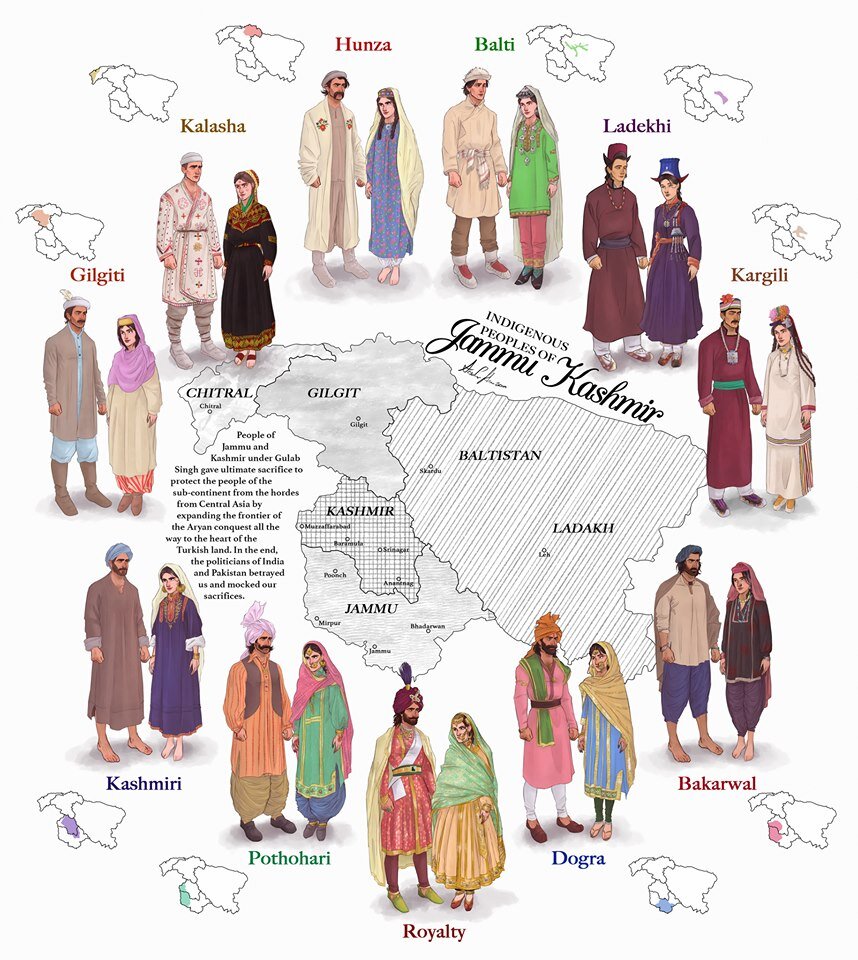
The Indigenous people of Jammu and Kashmir
Hunza / Gilgt and around : Besides Gilgit and Hunza there were other Hill States which used to be constantly at loggerheads with each other but used to occasionally unite against foreign aggression. These were Iskoman, Nagar, Yasin, Ghizer, Punial and Darel among the more notable ones. Gilgit was an important location and one of the most forward bases of the British in the Great Game which I have described in this article titled The Gilgit Game. In addition to these there were various other smaller “Shinaki Republics” which as the name suggests were Groups of Shina speaking people in communities in the area generally named as Chilas. The Imperial Gazzette of 1908 described them as such :
“A group of small republics in the valley of the Indus, lying west of Kashmir and south of Gilgit. The territory extends from the junction of the Astor river with the Indus to Seo on the right bank and Jalkot on the left bank of the latter river. Within this area the people are grouped in communities inhabiting one or more nullahs, each community forming a separate republic. Starting from the junction at Ramghat these are, in order : on the right bank, Gor, Kinergah, and Hodar ; and on the left bank, Bunar, Thak, Butogah, Giche, and Thor. They constitute the area known as the Chilas subdivision of the Gilgit Agency, while Chilas proper includes Kinergah, Butogah, and Giche. Lower down the river are Darel, Tangir, Khilli, and Seo on the right bank, and Harban, Sazln, and Jalkot on the left bank.
After the conquest of Chilas by Kashmir in 1851, the Maharaja imposed a tribute in gold-dust, and arranged for the administration of the country as part of the Gilgit district. A British Agency was re-established at Gilgit in 1889, which included, among other terri- tory, the Chilas subdivision described above except Thor. In 1892 a British mission to Gor was attacked by the Chilasis, which led to the occupation of their country and the appointment of a Political officer at Chilas. The right of the Kashmir Darbar to construct roads and station a limited number of troops in the territory was secured, but the autonomy of the Chilasis was guaranteed. Under the revised arrangements made in 1897 the republics pay small fixed sums to the Maharaja, and in 1899 Thor was incorporated in Chilas. Darel has rendered a tribute of gold-dust to Kashmir since 1866, when the Maharaja's troops raided the country. The tribute is now paid through the Punial governor. Tangir pays a small tribute to the governor of Yasin. The remaining communities have no political relations with either Kashmir or British India, except Jalkot, which from its position dominates Thor and the head of the Kagan valley in the North- West Frontier Province.”
Then on the other side we have Baltistan and Ladakh about who most people know a bit of the History and how these were conquered by General Zorawar Singh between 1834 and 1840. This is a brief account of the conquest of Ladakh and Baltistan by the Dogras. In Ladakh also once the Royal family was removed from Leh, the Ladakhi King was granted the Village of Stok and some surrounding area as a Jagir. Thats where the Stok Palace was built. Much the same way the Raja of Zanskar was granted the Jagirdari of Zangla. Or something to that effect. This is a general note on Zanskar to help in the understanding of this one of the most remote regions of the Himalayas. And ignore the Shaksgam part as its shown beyond its size. This article gives you an insight into the Shaksgam Valley. Another important part of the State which is missed out in this map is the region between the Karakorams and the Kun Lun Mountains called the Aksai Chin.
And then of course we have the Kashmir Valley itself. It was divided into North and South Kashmir for administrative purposes. To the West of Kashmir was Muzaffarabad which was the Pahari area along the Jhelum Valley starting from Uri. This is the part I belong to close to the town of Hatiann Bala. Muzzafarabad is also the Capital of the entity referred to as “Azad Jammu Kashmir”.
Then of course we have Poonch which was a Jagir granted to the family of Raja Suchet Singh, a brother of Raja Gulab Singh. It had a history of its own and struggled for a while to be independent of their Jamwal Cousins which only resulted in the Jagirdari being terminated for a bit. Here is an account of what transpired in the Kingdom of Poonch. There was also the very small Jagirdari of Chenani, which is a small Town on the Highway and I remember that there used to be a Palace of sorts over there. More than that I remember because the erstwhile Raja of Chenani was a friend of my Grandfather’s and i have seen him at my Grand Fathers’ place when I was very young.
And then there was Rajouri which is the stronghold of the Gujjars and most of them are based here during the Winters. Next to Rajouri was Mirpur which was really a part of Punjab and the people were called as Mirpuris. Due to the building of the Mangal Dam many Mirpuris went to the UK and thats the reason you have a strong Mirpuri community in the UK.
And then we had the Duggar heartland of Jammu and Kathua which bordered Chamba with which it shares a lot of Cultural similarities. The district of Udhampur at that time included the whole of Udhampur and Ramban as well as Doda and Kishtwar. The Jagirdari of Badh or Bhaderwah was granted to the Ruler of Bhaderwah who was installed by Gulab Singh after getting the Chambyalis to give up all their claims over Bhaderwah. It used to be an integral part of the Chamba Kingdom. This is an account of Bhaderwah. It connects with Chamba over the Padri Gali.
Of course this will get many people excited and there would be counter views but the views mentioned above are my own based on what I have read and experienced. Kindly feel free to disagree. But as a request just dont start a discussion 1947 onwards as it wont get us anywhere.
This Map is available in hi-res as well. Do let me know if you want.
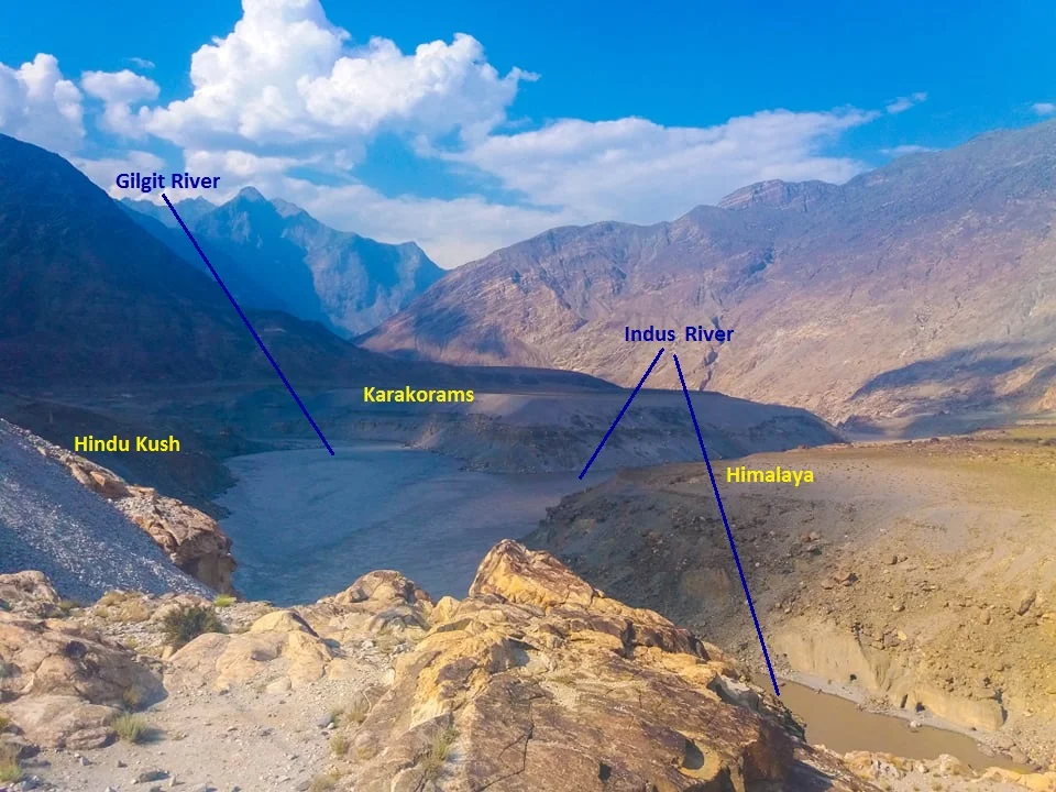
The Junction of the Three Mightiest Mountain Ranges
Jaglot near Gilgit is the point where the Three Mightiest Mountain Ranges of the world the Himalayas, the Karakorams and the Hindu Kush meet at the confluence of the Gilgit River with the Indus River

The Point where the Himalayas, the Karakorams and the Hindu Kush meet. At the confluemce of the Gilgit and the Indus Rivers.
The Place where the Himalayas, the Karakorams and the Hindu Kush Meet
Have you heard of Jaglot ?
It's a small little nondescript Village around 40 kms from Gilgit town which would have remained as such if not for a Geographical feature that the place holds. This point is located where the mighty Indus meets the Gilgit River in Gilgit Baltistan as the region is now called. This place is considered the meeting of the three mightiest Mountain Ranges in the World, the Himalaya which is home to 9 of the 10 highest Peaks in the World including the highest one Mt. Everest, the jagged Karakorams which is home to the K2 and the third one coming from the North West, the Hindu Kush which is come to the Tirich Mir which at 7708m is the highest Peak outside of the Himalayas-Karakoram Mountain System.
One of the oft asked questions is that is the Karakoram a sub Range of the Himalayas ? The answer is both no and yes and it depends on how you want to answer. They are in pure scientific terms different Ranges but a part of the same Mountain Complex that are referred to as the Great Himalayas.
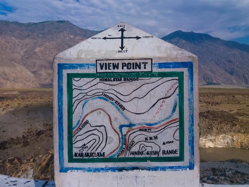
The point of convergence of the three Highest Ranges in the World !
Technically both are different Ranges as they were formed at different stages of one cataclysmic Event namely the collision/ subduction of the Indian Plate under the Eurasian Plate. Both follow their own separate Thrust lines and to really understand it you really need to get into Plate tectonics and understand stuff as I present to you below. This is taken from A Tectonic framework of the Himalaya, Karakoram and Tibet, and Problems of their Evolution by B F Windley :
“The Himalaya, the Karakoram and Tibet were assembled by the successive accretion to Asia of continental and arc terranes during the Mesozoic and early Tertiary. The Jinsha and Banggong Sutures in Tibet join continental terranes separated from Gondwana. Ophiolites were obducted onto the shelf of southern Tibet in the Jurassic before the formation of the Banggong Suture. The Kohistan--Ladakh Terrane contains an island arc that was accreted in the late Cretaceous on the Shyok Suture and consequently evolved into an Andean-type batholith. Further east this Trans-Himalayan batholith developed on the southern active margin of Tibet without the prior development of an island arc. Ophiolites were obducted onto the shelf of India in the late Cretaceous to Lower Palaeocene before the closing of Tethys and the formation of the Indus--Yarlung Zangbo Suture at about 50 Ma. Post-collisional northward indentation of India at ca. 5 cm a-1 since the Eocene has redeformed this accreted terrane collage; palaeomagnetic evidence suggests this indentation has given rise to some 2000 km of intracontinental shortening. Expressions of this shortening are the uplift of mid-crustal gneisses in the Karakoram on a late-Tertiary breakback thrust, folding of Palaeogene redbeds in Tibet, south-directed thrust imbrication of the foreland and shelf of the Indian Plate, north-directed back-thrusts along the Indus Suture Zone, post-Miocene spreading and uplift of thickened Tibet, giving rise to N--S extensional faults, and strike-slip faults, which allowed eastward escape of Tibetan fault blocks.”

The Public Viewing Point.
Now coming back to more simpler stuff as in Geographical terms the Karakorams are separated from the Himalayas by the Indus in its Upper Course. However in Ladakh the division is taken as the Shyok instead of the Indus. So when you are in Nubra Valley the Mountains on the other side of Shyok River as the Karakorams and this side as the Himalayas. However some people stick to the classical Indus division and by that norm the Ladakh Range would be part of the Karakorams and not the Himalayas. By the same definition Leh would be in the Karakorams and not the Himalayas.
However this ambiguity disappears once the Shyok River merges with the Indus at a place called Keris near the town of Skardu. The Nubra river also joins the Shyok in Nubra Valley and the River widens significantly. The fact that both these Rivers do a complete turnaround of 180 degrees from their original sources indicates the presence of fault lines.
The Hindu Kush on the other hand is separated from the Karakorams by the Gilgit River. The Gilgit rises somewhere between the mountain vastness of the Hindu Kush and the Karakorams. And it passes through Gilgit Town and eventually the joins the Indus at Jaglot. This is where eventually these three mighty Ranges meet. Of all the places that I would want to visit one day this would definitely be on the top.
If the ancients would have been able understand the significance of this location (which we do now due to years of research aided by modern scientific equipment) they would have built some great structures over here I would imagine. However there are still local legends about this place ie where the Indus meets the Gilgit (the legend has no relation to the meeting of the Three Great Ranges). As per the legend Fairies and other such creatures come to have a bath here at midnight or something on that lines.
So do note the name down. I'm sure you would like to go there.
The Gilgit Manuscripts
The Gilgit Manuscripts discovered in the early 1900s in Gilgit are one of the oldest Buddhist Manuscripts discovered in India. Believed to be one of the most revered Buddhist scriptures, it represents the discourse delivered by Buddha towards the end of his life.

A leaf from the Gilgit Manuscript
The Gilgit Manuscripts : A Treasure Forgotten
A couple of cattle grazers in 1931, in a village Naurpur near Gilgit once came upon a wooden box in a circular chamber in side a Buddhist stupa which contained a large number old Manuscripts pertaining to Buddhism. Little did they know that they had stumbled upon one of the most important finds of the century. The Gilgit Manuscripts are the oldest surviving religious Manuscripts from the sub-continent and of the oldest ones in Buddhism.
The cattle grazers took the collection to the Wazir of Gilgit who in turn turned it over to the Maharaja of Jammu and Kashmir and the news of the discovery of this Great Treasure spread world wide. Opinions vary about the date of this manuscript. One branch of scholars says it was written in the second century AD., while another puts the date at somewhere between the sixth and seventh centuries.
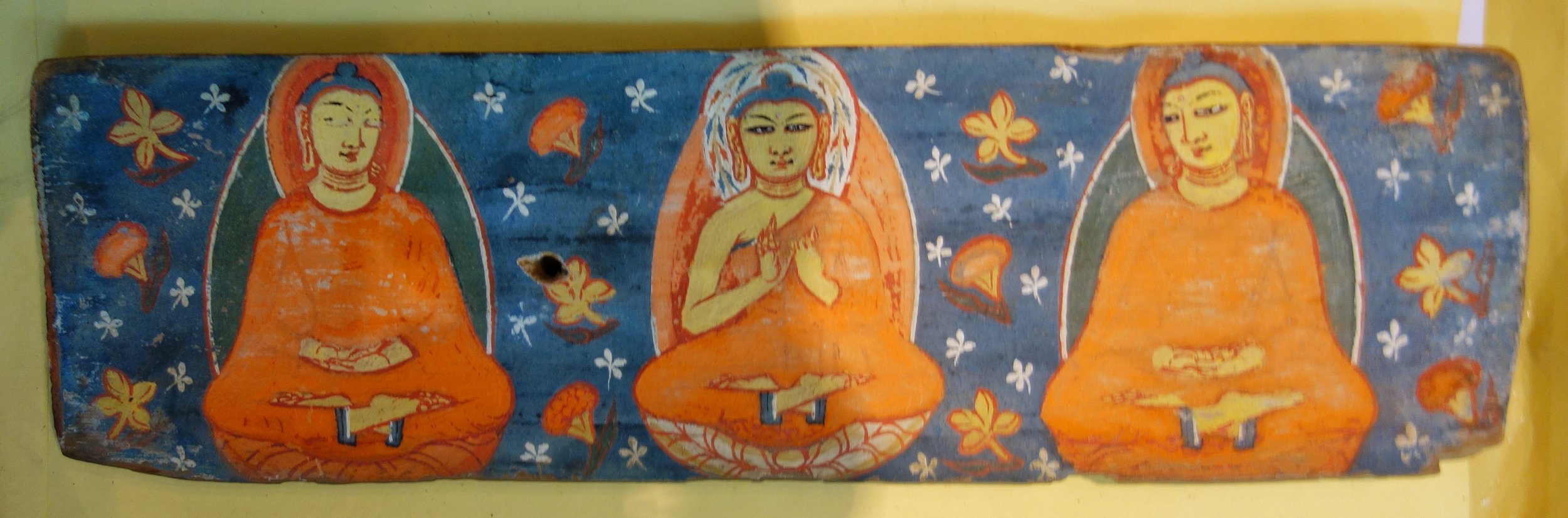
The Hand Painted Covers in which the Manuscripts were kept
Gilgit was at that time at the cross roads where South Asia, Central Asia and Eastern Asia met and it was an important stop on the Silk Road. Many monks from India carried the message of the Buddha from here to Tibet, China, Korea and even as far as Japan. It was along the Silk Road that Buddhism spread eastwards towards the rest of Asia. Gilgit hence played an important part in the spread of Buddhism and hence this find.
The almost seventeen centuries old Gilgit Manuscript has been giving historians a hard time, as no one has yet been able to fully decipher it. The lamination of the manuscript by the National Archives of India sometime ago has once again put the limelight back on this all-important literature concerning India, Tibet, China, Japan and other neighbouring countries.

Another leaf from the Gilgit Manuscipt
In fact in 1897 - 34 years before it was discovered - the Buddhist Text Society of Calcutta had published references to the Gilgit Manuscript saying that if it were ever to be found it would unravel the ancient history of several communities as it is considered to be the oldest Buddhist manuscript.
A corpus of many Buddhist texts such as the Four Sutras from the Buddhist canon, including the famous Lotus Sutra, the Manuscripts survived because they were written on the bark of the Bhoj (Birch) Tree which does not decay and obviously helped by the sub zero temperatures in Gilgit. They were written in the Buddhist form of Sanskrit in the Sarada or the Sharda Script. The Gilgit Manuscripts deciphered thus far cover a wide range of subjects such as religion, religious rituals, philosophy, iconometry, monastic discipline, folk tales, medicine and culinary art.
The most famous of the Gilgit manuscripts, the Gilgit Lotus Sutra is preserved in the National Archives of India in Delhi. Known as the Saddharma Pundarika Sutra – or the teachings of the white lotus and sun – the sutra is the basis of the Tiantai and Nichiren schools of Buddhism. In 2012 a facsimile edition of it was published by by the National Archives jointly with the Institute of Oriental Philosophy and Soka Gakkai, a Japan-based non-governmental organization.

Another cover for the Gilgit Manuscript
"In August 1938, seven years after the discovery of the texts, the archaeologist Madhusudan Kaul Shastri led a systematic excavation of the Naupur site and discovered another larger chamber at the base of the structure. The chamber contained another set of the Gilgit Manuscripts along with votive objects and probably Buddhist cult bronzes.
"According to renowned scholar Karl Jettmar, inscriptions on these bronzes “reveal that they were produced and dedicated due to the generosity and the religious zeal of a Patola Shahi”. The Patola Shahis, also known as Palola Shahis, were the rulers of Gilgit and Baltistan from the late sixth to the early eighth centuries AD.
"Shortly after, Kaul Shastri and his team outlined the specifications of the second group of manuscripts and other finds from the site including the hand painted covers of two manuscripts.
"In the third phase, the well-known Italian scholar Giuseppe Tucci secured another small group of the manuscripts in 1956. Obtaining them from a street vendor in Rawalpindi, he presented them to the Karachi museum.
"Roughly 60 manuscripts and 17 Avadnas emerging from Naupur are of unmatched significance in Buddhist studies. These are the oldest surviving collection of religious texts in the subcontinent. Based on the paleographical evidence, scholars agree that local Buddhist devotees compiled these texts between the fifth and sixth century AD. With the exception of only a few scripts, all the manuscripts were written on birch bark in Buddhist hybrid Sanskrit language in the Gupta Brahmi and post-Gupta Brahmi script.

More leaves from the Gilgit Manuscript
"The manuscripts contain sutras from the Buddhist canon, the Samghata Sutra, Samadhiraja Sutra, Saddharma Pundarika Sutra, and Bhaisajyaguru Sutra.The Samadhiraja Sutra is one of the important Mahayana canonical texts, which are collectively called Navadharma. The Saddharma Pundarika Sutra, popularly known as Lotus Sutra, figures prominently in the Gilgit Manuscripts and scholars agree it was the most venerated sutra of the Buddhists from the Gilgit area"
Though the grammatical and literature aspects of the text are gradually becoming more of historical interest in the contemporary world, what is of interest is the social relevance of some of the sutras mentioned in the manuscript. Experts feel that when the full text is deciphered a common thread will be found in the language and people of countries like India China, Japan, Thailand, Tibet and Korea which would have the potential of altering the very geo-political map of the region.
At present the main collection is with the National Archives in New Delhi and some parts with the British Museum in London and at the Karachi Museum. Apparently Nehru had the many body of the Manuscripts bought by a special Plane from Srinagar in 1948 after the Tribal Invasion. However a small part of the manu scripts still lie at the Shri Partap Museum in Srinagar though not on display.
The importance of the Gilgit Manuscripts can be guaged from this Report in the BBC :
http://www.bbc.com/news/world-asia-india-17935041
As luck would have it I managed to have a look and some parts of this Great Treasure at the Sri Partap Singh Museum yesterday and was even allowed to take pics. :)

Some more leaves
To come face to face with such a great treasure is truly a humbling experience and I could not help but tremble with excitement as the significance of what I was going to see. This is the Holy Grail of Buddhist Learning.
NOTE : Compiled from nformation on the Gilgit Manuscripts from various references on the Net.
PS : The Museum plans to put this on Display as it is shifting to a new Building and some Galleries are already open for Public viewing. The Museum has a great collection and is a must see when you visit Srinagar. I will try and share more treasures from the Museum here.
Markhor / Ibex Hunting
The Markhor and the Ibex are both magnificent animals found in the Himalayas, the Karakorams and the Hindu Kush. These animals were on the brink of extinction but now with creation of safe havens and conservation efforts they are making a comeback. Controversially the money raised by auctioning animals for legal hunting has contributed to the conservation effort.

Legal Markhor / Ibex Hunting
There was an Ibex shooting Video posted here which inevitably turned into a stupid India Pakistan blame game. The reality is that hunting of certain number of animals like Markhors and Ibex is legal in Pakistan. And the Video posted was from somewhere in Gilgit. Here is something I had posted on another Group. Posting it here to bring to light some facts :
The Markhor is a beautiful animal of the wild Goat family found from Kashmir to Afghanistan in the Himalayas/ Hindu Kush/ Karakoram and in the Pamirs in Tajikistan and Uzabekistan.
The Markhor is also the National Animal of Pakistan. The species was classed by the IUCN as Endangered until 2015 when it was downgraded to Near Threatened, as their numbers have increased in recent years by an estimated 20% for the last decade.
That being said the Pakistani Government issues annual licences for Hunters to take down a limited number of these magnificent animals who are apparently unable to breed. Hunters from abroad usually pay a high amount to get a hunting license for the same. Last year the license for the most expensive Markhor was a 100,000 USD. Plus all the other costs that go with the hunt. The money in turn is used by the Pakistani Government for the conservation of the species. And it seems to be showing results.
I have never been able to subscribe to the fact where you allow the hunting of a species for the preservation of the same species. Sounds kinda contradictory but it seems to work.
I just imagine what would the same people pay for hunting say, a Snow Leopard.
What are your views on the same ?
Ladakh / Baltistan / Gilgit Story
We try an together the story of Ladakh, Gilgit and Baltistan and how they became a part of the erst-while Riyasat of Jammu and Kashmir.

Ladakh / Baltistan / Gilgit Story
As a second part of my series on the state of Jammu and Kashmir and its complex geography / history. I wont get into the history of Kashmir Valley as it is usually well known. Please note that what I write below is from an Indian POV of the history of the region.
In this part I will try and comment on the Ladakh region and Gilgit Baltistan, the Trans Karakoram Tract (Shaksgam Valley) and last but not the least Aksai Chin. Out of all these regions most parts of Ladakh is under Indian control as well as a tiny part of what used to be the Baltistan Wazarat. All the rest are under de facto Chinese and Pakistani control and visiting these is impossible for Indian citizens so all what I state here has been through different sources in Books and on the Internet. Please note that to really understand the Geography at present we will need to dwell into History as to how things ended up how they are today.

The Zorawar Fort , Leh
We start off with Ladakh which is geographically and culturally much closer to Tibet and was usually referred to as Western Tibet by the Europeans. Ladakh was first conquered by the Sikh / Dogra armies led by General Zorawar Singh. As per a Treaty with the British, Maharaja Ranjit Singh’s was free to add territory to the North of the Sutlej River but not to the South of it. Jammu was already held by the Dogra Raja Gulab Singh who was a vassal of the Maharaja. Kashmir was already held by the Sikhs in the 1820’s and was ruled by an appointed Governor from the Court of Ranjit Singh.
Due to some bad blood between the Governor and Raja Gulab Singh, General Zorawar Singh was forced to go through Kishtwar on his first expedition to Ladakh. He ended up entering Ladakh region through the Suru Valley and went on to subjugate the whole of Ladakh in a series of expeditions starting in 1836.

The first engagement between Zorarwar and the Ladakh Army took place around here in the Suru Valley.
After the conquest of Ladakh, General Zorawar turned his attention towards Baltistan and Skardu. As it happened one of the sons of the Raja of Skardu/ Baltistan, Muhammed Shah, sought his help in a war of succession for the Skardu throne. Not one to let go of this opportunity General Zorawar Singh went on to invade Skardu and after a tough campaign finally managed to add Skardu and Baltistan to the Sikh Empire with Muhammed Shah as the nominal ruler paying an annual tribute to the Sikhs. Another contingent of his Army went on to conquer Astore.
Zorawar Singh was subsequently killed while on a campaign in Tibet and the Tiebtan and Chinese forces re-occupied Leh and most Ladakh. But subsequently the Sikh / Dogra armies returned, wanting to take revenge for the death of their beloved General Zorawar, and they ousted the Tibetan Chinese combined forces from Leh and subsequently a Treaty, the Treaty of Chususl, was signed between on the behalf the Sikh Maharaja and the Dogra Raja on one side and the Tibetan Dalai Lama and the Chinese Emperor on the other side, which demarcated the border pretty much as it stands today. Ladakh was hence ordained to be a part of India as the Chinese/Tibetans gave up all claims over it. The Treaty stated

The Village of Chushul where the Treaty of Chushul was signed.
“As on this auspicious day, the 3nd of Assuj, samvat 1899 (16th/17th September 1842) we, the officers of the Lhasa (Government), Kalon of Sokan and Bakshi Shajpuh, commander of the forces, and two officers on behalf of the most resplendent Sri Khalsa ji Sahib, the asylum of the world, King Sher Singh ji, and Sri Maharaja Sahib Raja-i-Rajagan Raja Sahib Bahadur Raja Gulab Singh, i.e.. the Muktar-ud-Daula Diwan Hari Chand and the asylum of vizirs, Vizir Ratnun. In a meeting called together for the promotion of peace and unity, and by professions and vows of friendship, unity and sincerity of heart and by taking oaths like those of Kunjak Sahib, have arranged and agreed that relations of peace, friendship and unity between Sri Khalsaji and Sri Maharaja Sahib Bahadur Raja Gulab Singh ji, and the Emperor of China and the Lama Guru of Lhasa will hence forward remain firmly established forever; and we declare in the presence of the Kunjak Sahib that on no account whatsoever will there be any deviation, difference of departure (from this agreement). We shall neither at present nor in the future have anything to do or interfere at all with the boundaries of Ladakh and its surroundings as fixed from ancient times and will allow the annual export of wool, shawls and tea by way of Ladakh according to
the old established customs.
Should any of the Opponents of Sri Sarkar Khalsa ji and Sri Raja Sahib Bahadur at any time enter our territories, we shall not pay any heed to his words or allow him to remain in our country. We shall offer no hindrance to traders of Ladakh who visit our territories. We shall not even to the extent of a hair’s breadth act in contravention of the terms that we have agreed to above regarding firm friendship, unity, the fixed boundaries of Ladakh and the keeping open of the route for wool, shawls and tea. We call Kunjak Sahib, Kairi, Lassi, Zhon Mahan, and Khushal Chon as witnesses to this treaty.”
Gilgit was again captured by the Sikh/Dogra forces in a repeat of events as they happened in Baltistan. One of the sons of the Raja of Gilgit sought the help of the Sikh Maharaja Sher Singh in expelling the Raja of Yasin who had conquered Gilgit. With the help of the Sikhs he was able to expel the Yasin Raja and Gilgit also became a vassal state of the Sikh Empire with a contingent of Sikh Army
permanently stationed there under Nathu Shah. With the passage of time the Sikh/ Dogra rule extended over to Yasin, Hunza, Darel, Chilas, Chitral and Nagar.

The Baltit Fort in Hunza
However the British took over the Gilgit Wazarat and called it as the Gilgit Agency. It acted as a listening post into Central Asia and more importantly it was just a few miles south of the borders of Imperial Russia and acted as one of the main stage where the Great Game in High Asia was played out. And the Brirtish pretty much ran the affairs of the Gilgit Agency and set up the Gilgit Scouts.
Thus the state of Jammu and Kashmir came into being as it existed on the day of independence.
It quickly unravelled after the British left who returned the Gilgit Agency back to the Maharaja. The Gilgit Scouts revolted against the Dogra Maharaja’s Governor on November 01, 1947. Brig Ghansara Singh, the Dogra Governor was taken prisoner and Gilgit was proclaimed, after some to and fro, as a part of Pakistan. The Commander of the state troops in Skardu, Col.Majid came in with re-enforcements for the Brig, but his own troops revolted and Col. Majid was also arrested. The Gilgit Scouts then turned their attention towards Skardu which had a garrison of the Maharajs’s state troops whose Commander Col.Majid was already in their custody. With no supplies coming in the Maharaja’s State troops were thought be easy targets by the Gilgit Scouts. Only they didnt factor in one fine detail. The second in command at the Skardu Garrison was a young Gurkha Officer, Major Sher Jung Thapa.
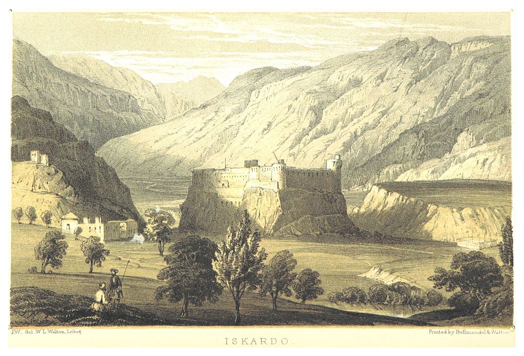
Skardu by Thompson 1852
The Gilgit Scouts attacked the Skardu Garrisson in February but the forces led by Maj. Sher Jung Thapa kept repelling all their attacks. The indomitable Gurkha Major held out for seven months until he rant out of all supplies and ammunition and he turned down many offers to surrender. Finally after firing the last bullet and throwing the last stone the Major finally surrendered on August 14. All the people in the Garrisson was put to the sword. All except Maj. Thapa who was taken a prisoner and later repatriated to India. The Indian Government decorated him with a Maha Vir Chakra and he was named “The Hero of Skardu” and was inducted into the Indian Army. He went on to become a Brigadier in the Indian Army and after retirement he peacefully passed away in 1999 in New Delhi.
The different acts of valour notwithstanding almost the whole of Gilgit Baltistan was lost and at the same time Ladakh was held onto inspite of great challenges.

The Khorpocho Fort overlooking the Indus at Skardu.
As for Aksai Chin it was always an uninhabited area and was not seen worth as keeping a garrison on. The boundaries were never officially recognized by the Chinese and the Kashmir Maharaja/ British Authorities. At present the Indian claim is based on the Johnson Line of 1865 where as the Chinese claim till 1959 was the MacCartney MacDonald Line of 1899. After 1959 however the Chinese came across this line which resulted in the conflict of 1962 and subsequently most of Aksai Chin came under Chinese control. For Chinese the area holds importance as the Tibet to Xinjiang Road runs through this region.
The Trans Karakoram Tract or the Shaksgam Valley was ceded to China by Pakistan as a part of their boundary agreement which settled the borders between these two countries.
To think of how beautiful and challenging the mountains in this whole region are but due to events in our history we are unable to enjoy the beauty which now stands divided by man made borders.
Lets hope and wait
Kiki’s Blog
Stories from the Himalayas








Five years ago the Galwan Valley was in the News for the wrong reasons after a deadly clash between the Indian and Chinese Armies in the Valley located in Ladakh lead to many deaths on the contentious Border between the two countries in wake of continued Chinese intrusions into Indian territory.
This area along the Shyok River, of which the Galwan Nallah or the Galwan River which forms the Galwan Valley has been off limits to Civilians since long but now the Indian Government has decided to open up the area for Civilians and we were amongst the First Civilians to venture into this beautifully desolate part of the Eastern Karakorams in Ladakh. Earlier Civilians could only venture upto the Village of Shyok from where the Shyok River takes a U turn and flows in a Northerly direction.