
The Exploration of the Siachen or Rose Glacier
The Story of the Exploration of the Siachen Glacier. This Glacier, now said to be the highest Battlefield in the World, was first Explored and Mapped by a team led by a Lady Fanny Bullock. This is her Story as well as Guide to explaining the Siachen Glacier with its main features and Glaciers around it.

The Siachen Map
The Exploration of the Siachen or Rose Glacier
The Siachen Glacier. It must be the most talked about Glacier in the Himalayan Karakoram region. A Glacier that has got famous for reasons that are just Political and I would steer clear of that. But there was a time before Partition when it was just another wonder in the Wilderness of the Himalayan Karakoram Mountains. One of the largest Glaciers outside the Polar Regions and for the early Explorers it was hard to believe that such massive Glaciers could exist anywhere outside the Polar Regions.

Ms.Fanny Bullock (Pic Courtesy Wikipedia)
The credit for the initial Exploration and Mapping goes to a Lady Fanny Bullock and her husband William Hunter Workman. They were actually a rich couple who liked to Tour the World and once they happened to come to India for a Cycling Tour. It was then that they got introduced to the Himalayas and it proved to be a life-long affair. The couple made 8 trips thereafter climbing and exploring the Himalayan and the Karakoram Mountains. They made many notable explorations during these Trips and during one of these Trips Ms.Fanny Bullock also managed to climb the Pinnacle Peak during their explorations of the Nun Kun Massif. The Pinnacle Peak is a side Peak to these Twin Peaks and at 6930 m it was a world record for a Lady at that time. It should be mentioned that being rich, they could afford Italian Porters and Guides though they also took local support.

Ms.Fanny Bullock atop Pinnacle with a Poster calling for Woman to be allowed to Vote (Pic Courtesy Wikipedia)
However they seemed to have an issue with the local Porters and many of their Travelogues were full of complaints against the local Porters and their behavior. I assume that it was a Cultural thing more than anything else. Born is a rich aristocratic American family which then moved to Europe she was far removed from the hardships of the people in the Mountains and it seems that the Lady got on very well with the Mountains but never did get along with the people who inhabited the same Mountains. Many people also accused the couple of exaggerating their actual accomplishments and always longing to be in the limelight. And their Maps were far from accurate. But all said and done they explored some of the least and even never ventured into areas especially in the Karakorams and this included many forays onto the many large Glaciers that the Range held.
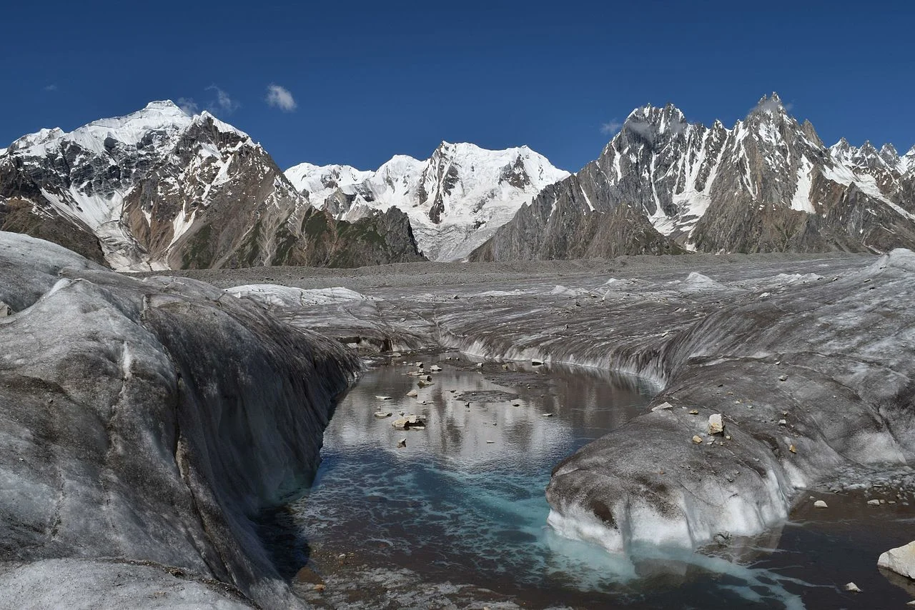
The Biafo Glacier (Pic Courtesy Wikipedia)
These Glaciers included the first attempt at the Biafo Glacier in 1899, an attempt they had to give up due to the Weather and the Crevasses so they moved onto exploring the Skara La Glacier instead. In 1902 they returned for the exploration of the Chogo Lungma Glacier. In 1907 they came to Kashmir and carried out the first exploration of the Nun Kun Massif. It was during this Exploration that at the age of 47, Fanny Bullock summited the Pinnacle Peak at 6930 m. Interestingly two years later a Lady competitor of hers claimed to have climbed a Peak in the Andes that stood at 7000m. But our Lady didn't believe her and actually paid an amount of USD 13000 to a Group of French Mountaineers to actually climb that Mountain in Andes and get the actual height. It turned out to be 6768 m. Fanny Bullock kept this Record to herself for a couple of decades.
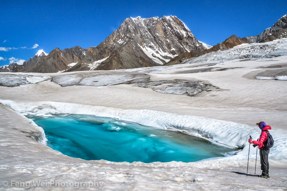
The Hispar Glacier (Courtesy Feng Wei Photography)
In 1908 the Lady with husband in tow arrived once again to explore the Hispar Glacier and even traversed across it and went to the Biafo Glacier setting another Record for ladies. They explored a number of side Glaciers and Peaks. In 1911 - 12 they finally decided to go and explore the biggest Glacier of them all. The Rose Glacier or the Siachen Glacier as we know it now. And they explored the Glacier and its sides for the two month period they spent there. It was a commendable piece of Exploration and as per all accounts this Exploration was led by Fanny Bullock herself. This was considered to be there greatest accomplishment and it also happened to be the last time in the Himalayan Karakoram Region due to the outbreak of the First World War.

A Wild Rose locally called a Sia (Pic Courtesy Wikipedia)
In her Book written after this Expedition, Two Summers in the Ice-Wilds of Eastern Karakoram , Fanny Workman writes : “The object of placing my full name in connection with the [Siachen Glacier] expedition ... is not because I wish in any way to thrust myself forward, but solely that in the accomplishments of women, now and in the future, it should be known to them and stated in print that a woman was the initiator and special leader of this expedition. When, later, woman occupies her acknowledged position as an individual worker in all fields, as well as those of exploration, no such emphasis of her work will be needed; but that day has not fully arrived, and at present it behooves women, for the benefit of their sex, to put what they do, at least, on record.”
And sharing the Map that was made by, as it came to be known as, the Fanny Bullock Workman Expedition of 1912 of the Siachen or Rose Glacier ( I am sure most of you are aware of the fact that the wod “Sia” in the local language stands for Wild Rose”). A very interesting Map indeed though not exactly accurate but still a great feat of Exploration, Mountaineering and Cartography.

The Indira Col and Turkestan La (Courtesy Josh Jagran)
Of course this is a Map which I love as to me its a work of art which has been worked hard at. And I have marked some important Passes which were used to access this Glacier (not that many people accessed this Glacier but these Passes were the ones used). The first one is of course the famous Indira Col at 18911 ft (The Workman Map wrongly describes it as 20880 ft) which is marked as Indira Col or Pass in the Map. No it isnt named after Indira Gandhi. It was named probably by the makers of this Map themselves as they gave names to all the features they saw as un-named in the Maps of their time that they were carrying (These Maps are described on the Map itself). They gave some features English names and some they gave Hindi names. Like the Indira Col (Named after Lord Indira) and Mt.Lakhsmi (self-explanatory) and they called a Group of Peaks as the “Apasaras”. Also itr signifies that the Indira Col was never used by the locals and hence never given a name. Its just too tough for anyone but a trained person.

The Kondus Glacier (Pic Courtesy the Amercan Alpine Journal)
Then there is the Bilafond La (No.2) at also known as the Saltoro Pass at 17881 ft on the Saltoro Ridge (The Workman Map puts the height at 18370 ft) . The name apparently comes from the Balti word for “Butterfly” or the Pass of the Butterflies. This was apparently one of the Passes that were used on the Silk Route which connected Ladakh and Baltistan with Central Asia. And then there is the Turkestan La (No. 3) said to be 19209 ft as per the Workman Map. This was probably another Pass into Turkestan as the area beyond the Karakorams referred to as. Not very significant anymore.

Dogs somewhere on the Siachen Glacier (Courtesy Wikipedia)
And then there is the Sia La (No.4) (The word Sia again derived from the local word for the Wild Roses that grew in the area). It stand at 18337 ft (The Workman Map puts the height as 18705 ft) on the main Saltoro Ridge. Further down is the Gyong La Pass which is not marked in the Map.
And then the Map also shows numerous side Glaciers and big Glaciers in the neighbourhood of the main Siachen Glacier. Like from below or the West the Kondus / Kaberi Glacier, the Bilaphond and Lolophond Glaciers, the Sher-Pi-Gang Glacier and the Peak 36 Glacier. Above or on the East (left side) of the Siachen are the Urdok Glacier and the Tarim Shehr Glacier.

Jammu and Kashmir dispute Map by the UN.
Of course we are all well aware of the situation on the Glacier and I would like to point out that all the Passes mentioned above are well in control of the Indian Army and they control the access to the Glacier. So in actual Geographic terms India controls the Siachen Glacier. And all the area running North of the point NJ 9842. But thats about all I can say about that.
The Chakma Raja who gave away a Kingdom !
The Story of the King of the Chakmas, a Tribe found in the Chittagoing Hill Tracts who gave up his Kingdom and was at one time offered the President ship of the state of Pakistan. He ended up being an Ambassador to South America for decades and was the head of the Buddhist Society of Pakistan.

The Chakma Raja who gave away a Kingdom
In the highlands of Bangladesh called the Chittagong Hill tracts bordering Myanmar live a number of Tribes which are collectively referred to as the Jumma people by the majority Bangla population. The name derives from the the term Jhum cultivation which is also referred to as the slash and burn type of Cultivation wherein a tract of Jungle was cleared by slashing and burning and cultivation was then done there. t the time of Partition of India for some inconceivable reason these areas were ceded to “East Pakistan” though the population was mainly Tribal who practiced Theravada Buddhism.
The “Jumma People’ themselves are divided into various tribes all of whom have their own Religious practices though most have adopted Buddhism, there are still a few that are Hindu and Christian and even Muslim. Most of them still maintain some level of their indigenous animist beliefs as well. The main Tribes of the region are the Chakma, Arakanese (Rakhine), Marma, Tripuri, Tanchangya, Chak, Pankho, Mru, Bawm, Lushai, Khyang, Gurkha, indigenous Assamese, Keot (Kaibarta), Santal, and Khumi as per Wiki.
Among these people the most well known ones and the most dominant ones are the Chakmas. The Chakmas are Theravada Buddhists and many of them live across the Borders as well in India and Myanmar. In India they are found in almost all the states in the North East and even in West Bengal. The name Chakma is supposed to have been derived from the Sanskrit word “Shaktiman” as many Chakmas served in the Kingdoms of the Rakhine Kings and they wielded great power. The Chakmas themselves are divided into various Clans and reigning over all the clans is the powerful Chakma Raja.

Some of your must be aware that there was long running dispute between India and Bangladesh as a number of Chakmas had taken refuge in India citing discrimination and harassment by the Authorities in Bangladesh and this for long was a prickly issue with its roots going back to Independence. There still are Chakmas living in refugee Camps in certain areas of North East India.
At the time of Independence the Raja of Chakmas was Raja Nalinaksha Roy. Though the Chittagong Hill Tracts had a 98% non-Muslim population they were still assigned to Pakistan by the Boundary Commision. The Raja had come into power in 1935 and had Ruled for 12 years at the time of Independence. He acceded to East Pakistan as there little else he could do and was given Autonomy by the Pakistani Government to make him easier to win over. The Raja passed away in 1951 and after sometime as in Chakma tradition his eldest son Raja Tridev Roy was formally annointed as the 50th Chakma Raja in 1953.
Once the Mukti Bahini started its campaign in the 1960s the Chakma Raja decided that they will remain neutral as they didnt want to rub the Mukti Bahini or the Pakistani Army the wrong way. But Raja Tridev Roy became increasingly inclined towards the Pakistani Government. Infact Sheikh Mujibur Rehman offered him a seat to fight on behalf of the Awami League but Raja Sahib disagreed and instead stood up as an Independent and won the Seat though overall the Awami League got a landslide victory in East Pakistan. And soon after a series of Events the Liberation War, as the Bangladeshis called it started. But once again Raja Sahib sided with Pakistan as I think he assumed that the Pakistanis would hold ground. But things went rather the other way and Raja Sahib found himself in deep trouble. With his Allies close to defeat the Raja Sahib knew that life would be hard for him in an independent Bangladesh due to the stands he had taken. So he decided to abdicate.
Raja Tridev Roy abdicated in 1971 in favor of his eldest Son, the 12 year old Raja Devashish Roy. The Raja knew that even Abdication would not be enough as people would come to settle scores with him. Also he felt that the position of the Chakmas would become precarious in a new Bangladesh and their special rights and privileges would be taken away. He was in many ways right. The Raja had only one option now and he went over to West Pakistan or Pakistan as it came to be known thereon. He was welcomed very warmly on his arrival in Pakistan and conferred the status of a Federal Minister for life. But more was still to come.
The first task he undertook was to head the Pakistani Mission to UN which opposed the admission of Bangladesh to the United Nations. In answer to this the Bangladeshi delegation was led by the Chakma Rajamata Benita Roy who happened to be his Mother. I wonder what transpired between the Son and the Mother. Two Chakma Royalty Members, from the Hills of the North East, both devout Buddhists, headed important delegations from two countries which were overwhelmingly Muslim and with the largest Muslim populations besides Indonesia. It was indeed something straight out of a Thriller. Anyways Bangladesh became a Member of the United Nations and that was that.
However, Raja Sahib wasn't done yet and he joined the Bhutto Government. And when Bhutto became the Prime Minister of Pakistan he offered the Presidentship of Pakistan to Raja Tridev Roy. This was a great opportunity but it came with a rider. As per the new Constitution of Pakistan only a Muslim could become the President of Pakistan. And of course this wasn't acceptable to the erstwhile Raja Sahib of the Chakmas. So now after giving up the Kingship of the Chakmas, the Raja Sahib declined the Presidentship of Pakistan.
And then Gen. Zia came into power and Mr.Bhutto was hanged and all Bhutto loyalists came under the attack and none escaped the Generals wrath. Well all except the Raja Sahib. Bhutto knew better than to let any harm come to Raja Tridev Roy. Raja Sahib stayed active in Politics and there was little that Gen Zia could do to him but after a couple of years he decided he didnt want him to be around. So a new Role was found for the Raja Sahib and he was appointed as the Pakistani Ambassador to Argentina in 1981 and off he went to South America. And at the same time he was made the Ambassador to Chile, Ecuador, Peru and Uruguay. The Raja Sahib from what was considered the Himalayan foothills by many could now while his time in the Andes Mountains it seemed. And he stayed in South America for many years till the time Gen. Zia passed away.
After Gen Zias death Raja Sahib was brought back to the sub-continent at least from South America and appointed as the Ambassador to Sri Lanka. Being a Buddhist he made a good choice as an Ambassador to a Buddhist majority country. And finally in 1995 Raja Sahib returned to Pakistan after his Ambassadorial assignments abroad. He now turned his attention to working for the Buddhist Community in Pakistan and decided to devote more of his life to Religious pursuits and also became the head of the Pakistan Buddhist Society.
Raja Tridev Roy finally passed away in 2012 (less than 7 years back) due to cardiac arrest as his home in Islamabad. His House in E-7 had a Plaque on the outside and it said “Chakma House”. And he was largely alone when the end came. No one in Pakistan by that time had any recollection of the soft spoken King of the Chakmas who gave up his Kingdom and declined the Presidentship of Pakistan. No one really cared.
Do Google Raja Tridev Roy. Was a Handsome guy !
Pic from the Internet. Somewhere in the Chittagong Hill Tracts
The Murree Brewery
The Murree Brewery was established in 1860 the fulfill the ever increasing demand of Beer for the British Troops in the British Indian Army. It did roaring business till it was reduced to ruins after being burnt down during the riots in the wake of the partition of the British India.

The Ruins of the Murree Brewery in Murree.
The Murree Brewery
Murree Brewery was established in 1860 in response to the ever increasing demand for beer by the personnel of the British Raj, and is currently the oldest continuing enterprise in Pakistan.
Consequent to the British annexation of the Punjab in 1849 from Sikh rule, and more so after 1857 when the British Crown formally extended its sovereignty over India, a structured administration commenced in the Punjab.

The Ruins of the Murree Brewery in Murree.
To meet the beer requirements of British personnel (mainly army), the Murree Brewery was established in 1860 and incorporated a year later at Ghora Galli, located in the Pir Punjal range of the Western Himalayas at an elevation of 6000' above sea level, near the resort town of Murree.
Between 1885 & 1890 the Company established Breweries in Rawalpindi & Quetta & acquired an interest in the Oticumand (South India) & Norailiya (Ceylon) breweries. A distillery was also established in the above period in Rawalpindi next to the Brewery.

The Ruins of the Murree Brewery in Murree.
The Murree Brewery at Ghora Galli was therefore among the first modern beer breweries established in Asia. Murree Beer proved to be very popular among the British troopers who were largely barracked in the 'Galis' of these hills. The virtues of beer brewed from barley malt & hops as a light alcoholic beverage were not lost on the local population who rapidly became avid consumers.
By the turn of the 20 century, the name "Murree" was famous for its beer in keg and bottle in the bars, beer halls and army messes of British India. Murree Beer was first awarded a medal for product excellence at the Philadelphia Exhibition in 1876, followed by numerous awards over the past 140 years.
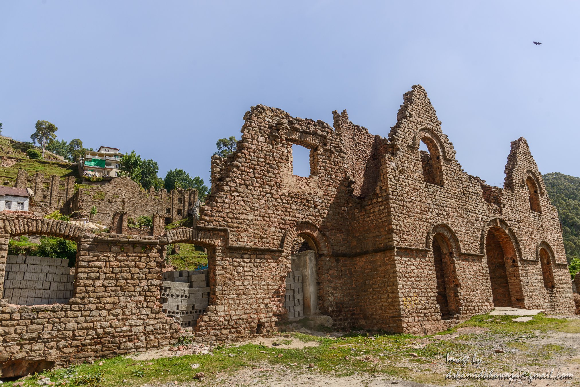
The Ruins of the Murree Brewery in Murree.
In 1935, a massive earthquake totally demolished the Quetta brewery as well as substantial part of Quetta town, killing thousands of persons, including a number of our employees. At Ghora Galli (Murree), the scarcity of water became an emerging problem. By the 1920s, brewing was mostly transferred to the Rawalpindi brewery but malting continued at Ghora Galli till the 1940s, when this property was sold. This historic brewery built in Gothic style architecture was burnt during the partition riots of 1947/48. The Ruins of the building still exist in Murree and are a testimony to the grandeur of the Brewery Building as it once stood.

Park Lodge a handsome residential property was purchased by the company from Mrs.H. Whymper in 1888. It was the principal residence and head office of the company till 1959, when it was taken over by the Government of Pakistan to house the office of the President of Pakistan. It remains an office of the Head of State of Pakistan from 1960 till the present day.
Two English families were closely connected with the founding of the original brewery. Edward Dyer was the first General Manager of the company. He was also the founder of Dyer Meaken breweries, Simla Hills. His son Gen.Dwyer attained notoriety for his role in the Jalainwala Bagh incident. Edward Whymper, a member of this family was the first person to climb Matterhorn mountain in 1865. The Rawalpindi brewery is blessed with deep aquifers of good water. A railway siding was extended to the premises in the 19th century, which is now derelict.

The Ruins of the Murree Brewery in Murree.
Markhor / Ibex Hunting
The Markhor and the Ibex are both magnificent animals found in the Himalayas, the Karakorams and the Hindu Kush. These animals were on the brink of extinction but now with creation of safe havens and conservation efforts they are making a comeback. Controversially the money raised by auctioning animals for legal hunting has contributed to the conservation effort.

Legal Markhor / Ibex Hunting
There was an Ibex shooting Video posted here which inevitably turned into a stupid India Pakistan blame game. The reality is that hunting of certain number of animals like Markhors and Ibex is legal in Pakistan. And the Video posted was from somewhere in Gilgit. Here is something I had posted on another Group. Posting it here to bring to light some facts :
The Markhor is a beautiful animal of the wild Goat family found from Kashmir to Afghanistan in the Himalayas/ Hindu Kush/ Karakoram and in the Pamirs in Tajikistan and Uzabekistan.
The Markhor is also the National Animal of Pakistan. The species was classed by the IUCN as Endangered until 2015 when it was downgraded to Near Threatened, as their numbers have increased in recent years by an estimated 20% for the last decade.
That being said the Pakistani Government issues annual licences for Hunters to take down a limited number of these magnificent animals who are apparently unable to breed. Hunters from abroad usually pay a high amount to get a hunting license for the same. Last year the license for the most expensive Markhor was a 100,000 USD. Plus all the other costs that go with the hunt. The money in turn is used by the Pakistani Government for the conservation of the species. And it seems to be showing results.
I have never been able to subscribe to the fact where you allow the hunting of a species for the preservation of the same species. Sounds kinda contradictory but it seems to work.
I just imagine what would the same people pay for hunting say, a Snow Leopard.
What are your views on the same ?
Kiki’s Blog
Stories from the Himalayas








Five years ago the Galwan Valley was in the News for the wrong reasons after a deadly clash between the Indian and Chinese Armies in the Valley located in Ladakh lead to many deaths on the contentious Border between the two countries in wake of continued Chinese intrusions into Indian territory.
This area along the Shyok River, of which the Galwan Nallah or the Galwan River which forms the Galwan Valley has been off limits to Civilians since long but now the Indian Government has decided to open up the area for Civilians and we were amongst the First Civilians to venture into this beautifully desolate part of the Eastern Karakorams in Ladakh. Earlier Civilians could only venture upto the Village of Shyok from where the Shyok River takes a U turn and flows in a Northerly direction.