

Karakorams in Ladakh
The Himalayas might be the highest Range in the World but when it comes to sheer perpendicularity nothing compares to the mighty Karakorams. Many people consider the Karakoram to be a part of the Himalayas but its not. Its a separate Range in its own right. It might be considered at a part of the Great Himalayan Complex of Mountains that radiate out of the Pamir Knot. In common parlance the term Karakoram is synonymous with its most famous Peak, the K2 or the Godwin Austen as it was once called. But other Peaks and parts of it are relatively unknown.
The Himalayas might be the highest Range in the World but when it comes to sheer perpendicularity nothing compares to the mighty Karakorams. Many people consider the Karakoram to be a part of the Himalayas but its not. Its a separate Range in its own right. It might be considered at a part of the Great Himalayan Complex of Mountains that radiate out of the Pamir Knot. In common parlance the term Karakoram is synonymous with its most famous Peak, the K2 or the Godwin Austen as it was once called. But other Peaks and parts of it are relatively unknown.
And surprisingly most people in India are unaware of the large slice of Karakorams which lies on the Indian side of the LoC as well on the Indian side with Tibet. Of course the fact that all of our Borders on the Karakoram are disputed and as such getting Permissions for exploring these Regions are far and in between though in recent years there have been some Expeditions in the Eastern Karakorams led by Divyesh Muni Sir and his Team.

And the Karakoram is not a Monolithic Range and its has a number of quite distinct Sub Ranges which could be Mountain Ranges in their own right. It should be remembered that the name “Karakoram” was first used by Europeans for the Baltoro Range of the Karakorams which stretches from the point where the Nubra meets the Shyok and Northwards all the way to the Siachen Glacier. Now typically the Karakorams stretch from the Aksai Chin in the North East to the Tibetan Plateau and then it is bounded by the Shyok, the Indus and the Gilgit River towards the West.
Then there is the interesting Ladakh Range which runs between the Shyok and the Indus which run roughly parallel to each other for quite a length. As per some the Ladakh Range is a southern extension of the Karakoram while others consider the Shyok as the parting between the Great Himalayan Range and the Karakorams. So if we consider the first instance then even Leh lies in a part of the Karakoram Range. While as per others it lies in the Great Himalayan Range. The Britannica considers even the Pangong Range and the Chang Chenmo Ranges as parts of the Karakorams. Also the Kailash Range is considered a Southern extension of the Ladakh Range and so is the Deosai Range. The Mountains are complicated and especially the Karakorams.
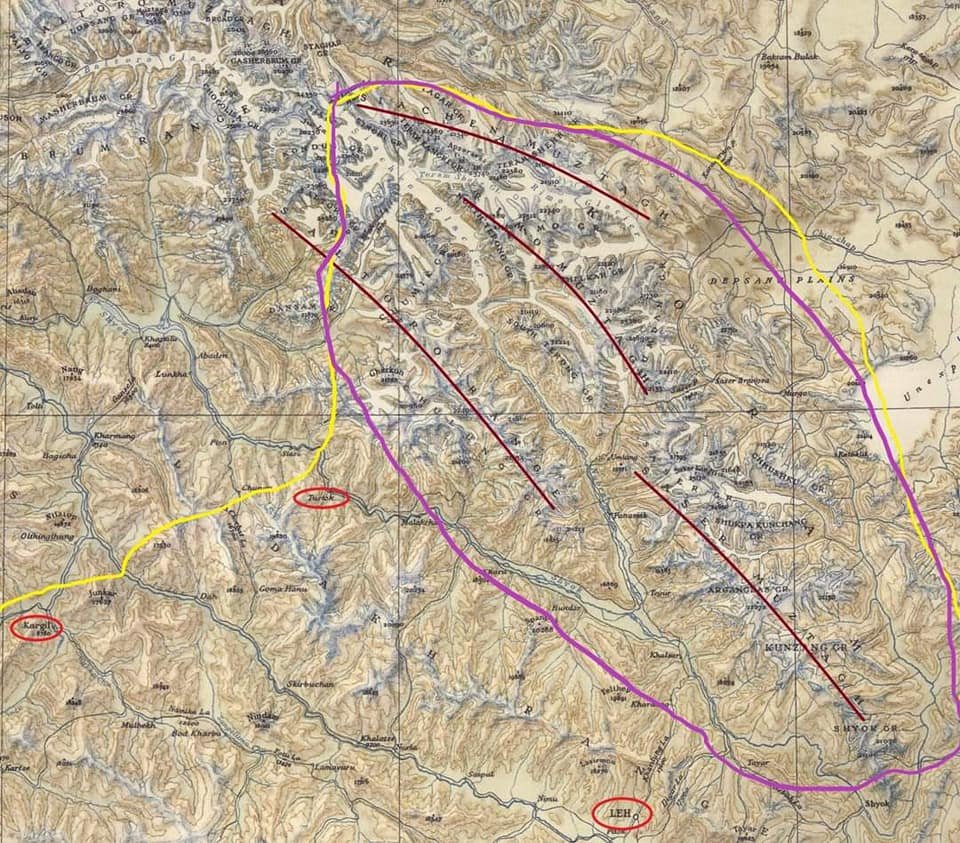
Now as for the main Karakorams it has a number of sub Ranges and out of these 3 lie fully on the Indian side and a 4th lies partly on the Indian side. The Sasser Muztagh is the southernmost sub Range of the main Range and lies between the bend of the Shyok when it changes direction and heads in a Northern direction. The Shyok rises in the Rimo Muztagh which lies above the Sasser Muztagh. The same trend is shown by the Nubra which also joins the Shyok and its at this point the Baltoro Sub Range starts which is partly on the Indian side. So the Sasser and the Baltoro Ranges are divided by the Nubra which rises in the Siachen Glacier. The Sasser La runs roughly between the Sasser Muztagh and the Rimo Muztagh. And in the extreme North along the Siachen Glacier runs the Siachen Muztagh.

And all these Sub Ranges further have different Groups of Peaks within them which Ill try and list below as given in the Royal Geographic Society Map of the Karakoram from 1939 as below :
Sasser Muztagh : Main Peak Groups
Shyok Group
Kunzang Group
Arganglas Group
Shukpa Kunchang Group
Chhusku Group
Sasser Group
Rimo Muztagh : Main Peak Groups
Rimo Group
North Terong Group
South Terong Group
Kumdan Group
Shelkar Group
Siachen Muztagh : Main Peak Groups
Teram Kangri Group
Teram Shahr Group
Singhi Group
Kyagar Group
Main Peaks (Out of the 20 Highest Peaks in India 12 Lie in the Karakorams)
Saltoro Kangri 7742
Sasser Kangri I 7672
Mamostong Kangri 7516
Sasser Kangri II 7513
Sasser Kangri III 7495
Teram Kangri I 7462
K12 7428
Ghent Kangri 7401
Rimo I 7385
Apsarasas Kangri I 7243
Rimo III 7233

Leaving you with a Classic Royal Geographic Map of the Karakorams in 1939 and a Map with some marked lines and places circled for reference. The Yellow Line is the LOC / Border while the Purple line is the extent of the Karakorams in India. (As in De Facto)
The Hindu Raj Mountains
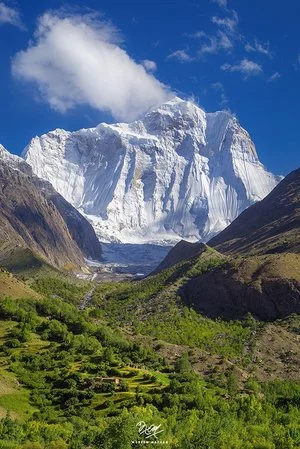
The Hindu Raj Mountains is a little known Mountain Range sandwiched between the Hindus Kush and the Karakoram Ranges located mostly in the Khyber Pakhtunkhwa Province of Pakistan. And till date many few people outside the region know of this Range which purists consider separate from the Hindu Kush Range.
The Hindu Raj Mountains
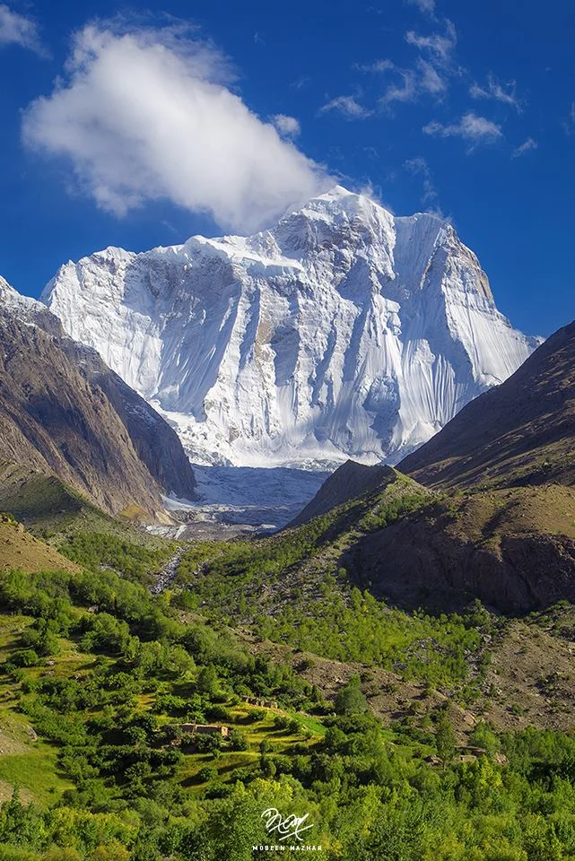
There lies somewhere in the Northern wilderness of Gilgit Baltistan and Khyber Pakhtunkhwa nestled between the mighty Karakorams and the Hindu Kush a Mountain Range called the Hindu Raj Mountains. Most people consider it a part of the Hindu Kush Mountains but many Geographers and purists consider the Hindu Raj as a separate Range. And surprisingly very few people have ever heard of it in the sub-continent. Though everyone is quite aware of the Hindu Kush Range and the many versions how it came to be named as such. The same should have been the case with the Hindu Raj but I guess someone missed the Memo.
The Hindu Raj Mountains are a noble Range in their own right but just like the Pir Panjals to the South across the Great Himalayan Range it gets dwarfed by the giant Peaks of the Karakoram and the Hindu Kush. Not that it lacks heavy weights just that in a Region which abounds with numerous 7000 m plus Peaks and even 8000 m plus Peaks the tallest Peak of the Hindu Raj Mountains, the Koyo Zum tops in at 6872 m (22,546 ft) which is by no means less but it just gets dwarfed as mentioned earlier. To put that height into perspective the tallest Peak of the Andes, the Aconcagua stands at 6962 m.
As per Encyclopedia Britannica “A wider definition of the Hindu Kush would include a fourth region known as Hindu Raj in Pakistan. This region is formed by a long, winding chain of mountains—with some lofty peaks, such as Mounts Darkot (22,447 feet [6,842 metres]) and Buni Zom (21,499 feet [6,553 metres])—which strikes southward from the Lupsuk Peak (18,861 feet [5,749 metres]) in the eastern region, then continues to the Lawarai / Lowari Pass (12,100 feet [3,688 metres]) and beyond to the Kābul River. (The Lowari Pass is a Pass which connects Dir in Khyber Pakhtunkhwa with Chitral which also falls in the same province. The Lowari Pass is the lowest of the 4 traditional Passes which connected Chitral with the outside world. The Lowari Pass is famous for its avalanches and the number of people who died on it historically. Think of it like you think of the Rohtang or the Zoji). If this chain is considered part of the Hindu Kush, then the outlying mountains of the Swat Kohistan region of Pakistan to the south also form part of the complex.”
As per another definition by “Batholith Saltoro” the range that lies between the true left bank of the valley of the Yarkhun/ Mastuj River in the West and North and the Northern watershed of Swat Kohistan in the South, is the Hindu Raj. The main range of the Hindu Kush lies to the East and North of the Yarkhun/ Mastuj/ Chitral/ Kunar River system.
Now most of us are familiar with the Etymology of the Hindu Kush which as per one definition meant the “Killer of the Hindus” which was a reference to the fierce avalanches that the Hindu Kush would let loose. It was also supposedly a reference to the large number of people from the subcontinent who were taken as slaves to Central Asia across the Hindu Kush and many perished while crossing this formidable Mountain Range. But as per the Encyclopaedia Britannica the term Hindu Kush is derived from Arabic and it simply means the Mountains of India. But then this is a debatable issue and we leave it as such to ponder over it another day.
So I assume the Hindu Raj reference must have come from the Hindu Shahi Rulers who held power in this Region. But this is just an assumption. You need to keep in mind that at that time “Hindu” was a geographic term and it still has but now it has a different connotation. Or since the area is in the same vicinity where the Kalasha people live maybe its a reference to them and their ancestors when most people here were Kalsha. This remains a matter of my personal speculation as I am yet to come across a source which mentions why exactly these Mountains were called the “Hindu Raj” Mountains.
And culturally also the area has a very interesting history. As per “Batholight Saltoro” “Culturally, the linguistic mixture is interesting, containing as it does a mixture of Shina, Burushaski, Khowar, Gujar, and Wakhi speakers which reflects the complex history of the area. It has been ruled variously from Chitral, both by the Kushwaqt and the Ul Mulk dynasties, from Gilgit, from Srinagar, from Tibet, from Persia. The original inhabitants of its Eastern Valleys seem to have been Burushaski speakers, preserving, as they do, what is considered to be a purer version of that language as compared to that which is spoken in the Hunza region. The Yasin valley, the pass at the head of which served as a conduit for the Chinese to invade and conquer the Tibetan held Lesser Bolor, is also the valley where the explorer/journalist George Hayward was murdered, perhaps for being a tad too investigative.
Another interesting Range in the Great Himalayan System now somehow obscured by other more famous Ranges / Sub ranges of the system.
On Flight of Fancy to Leh
A commentary on the Flight from Delhi to Leh which takes one over the Himalayan Range. It is one of the most spectacular Aeroplane journey for the sights it offers. Starting over the Plains, then over the Lower Himalayas or the Shivaliks, then over the Middle Himalayas / Pir Panjals and finally over the Great Himalayan Range itself before finally landing in the Trans Himalayan landscape of Ladakh.


The Great Himalayan Wilderness
On a Flight of Fancy to Leh
A flight to Leh from the Plains gives you an actual chance to view the awesomeness of the mightiest Mountain Range on the Planet especially just as Winter gives way to Spring and the Peaks have the maximum amount of Snow which accentuates the appearance of the Mountains.

The Lower Hills with the Rivers coming through
The endless Plains first give way to the lower Hills and the Shivaliks. Its just ahead and coming out of these lower Hills are a number of Rivers as they enter the Plains. And the effect of man's work is also visible as you see the Reservoirs of various Dams appear once into the lower Hills.
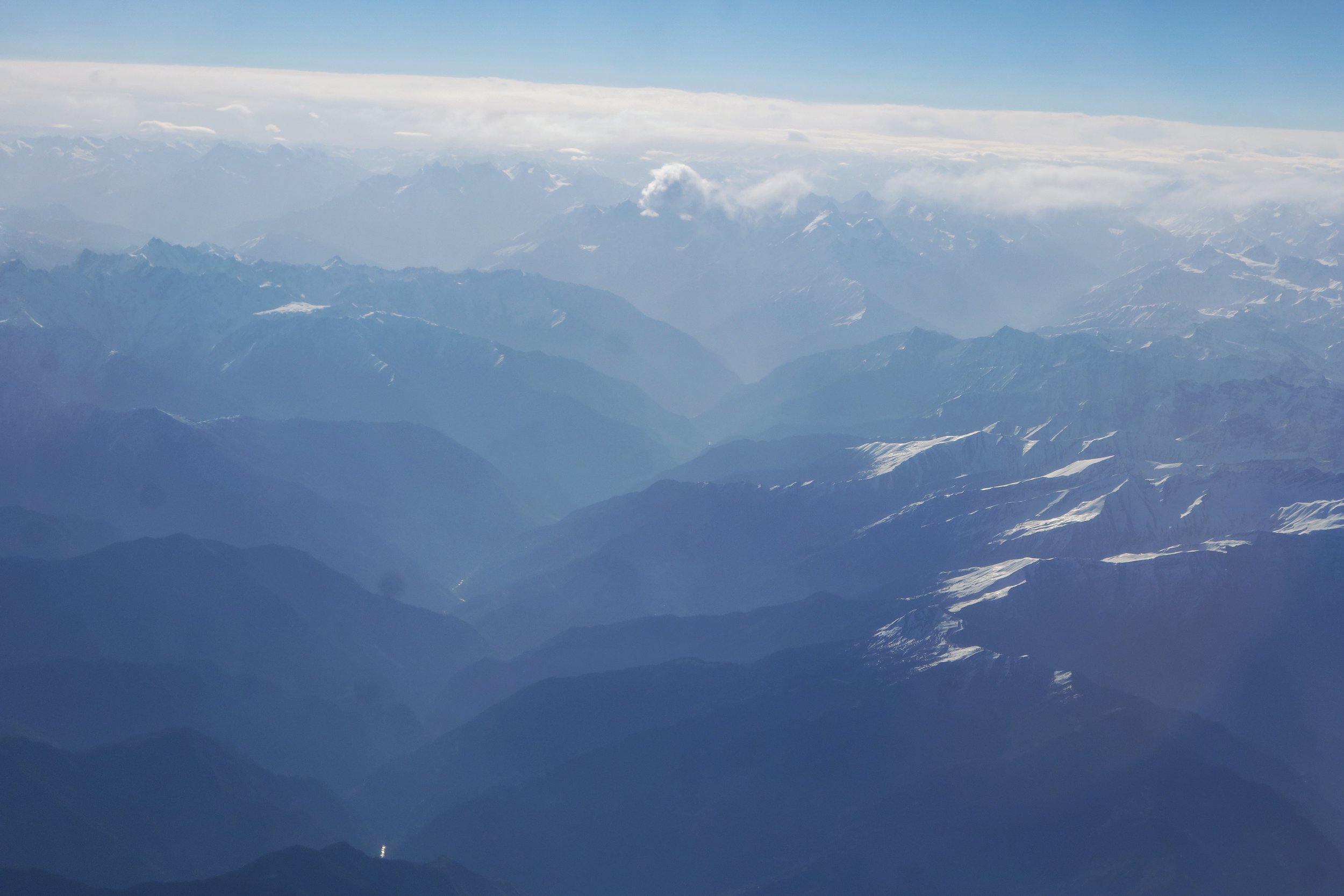
The Lower Hills giving way to the Lesser Himalayas at the Dhauladhars and the Pir Panjals.
The lower Hills give way to the Lesser Himalayan Ranges like the Dhauladhar and the Pir Panjals. These appear as big mountains with craggy tops and snow higher up with a some small Glaciers.

The Lesser Himalayas giving way to the Great Himalayas
Once across this suddenly you see an elevation in the lay of the land and suddenly till the eyes can see are visible craggy Peaks all white with massive Glaciers between the Massifs. This is the sign that you are now on the Great Himalayan Range itself. The main and the highest Spine of this Mountain Range. And it goes without saying this appears as the most dramatic part of the Range as its a virtual Ocean of thousands of Spires.

The Glaciers of the Great Himalayas

The endless Spires of the Great Himalayas
But like all good things must end so does this this.And then you start noticing that the landscape gets browner with lesser Snow and the Mounatins appear to be rounder rather than craggy. These are the Trans Himalayas. And also making their appearance are certain large water bodies that exist on this Trans Himalayan desert.

The Great Himalayas giving way to the Trans Himalayan Plateau
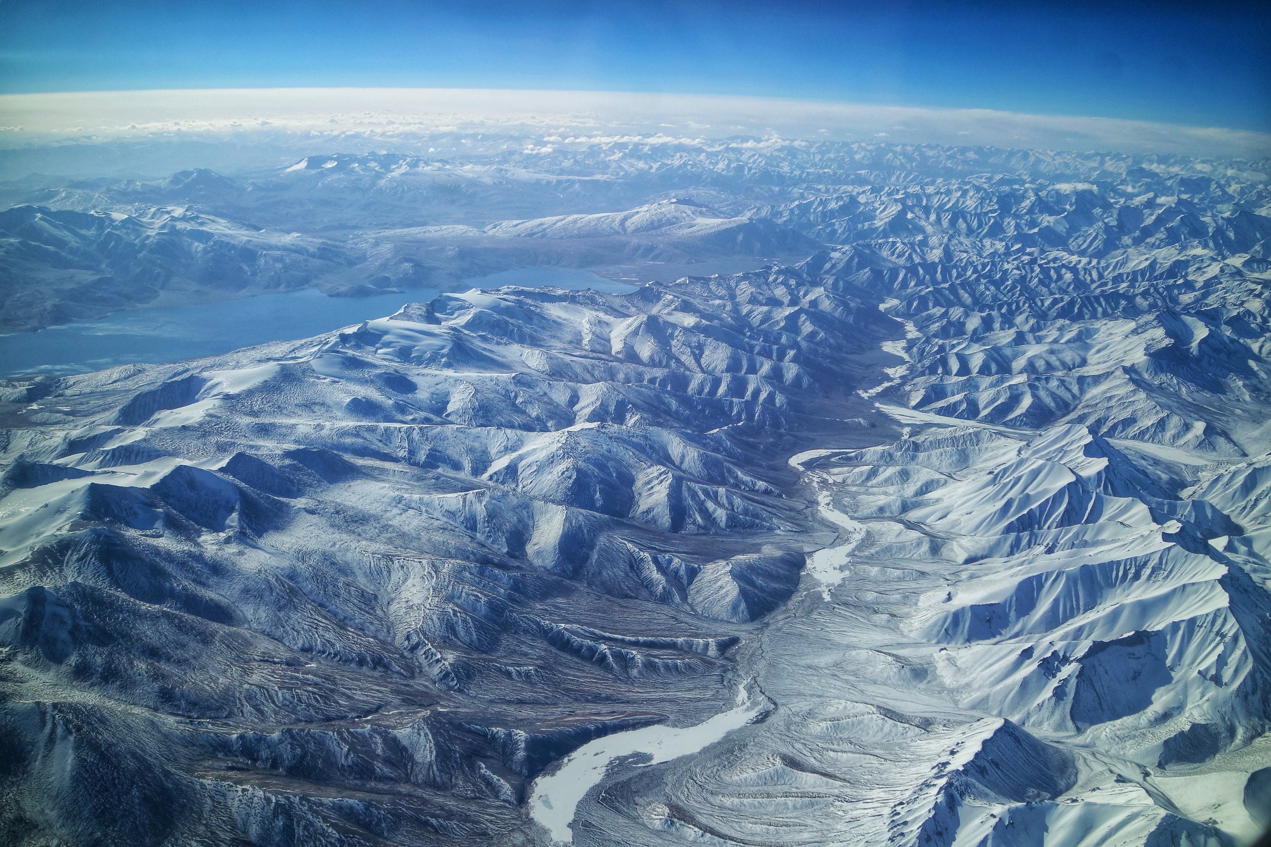
In the pic below you can see the dramatic change as you cross from the Great Himalayas over to the Trans Himalayas with a River acting like a border. The Mountains to the right of the River are craggier and whiter than the ones to the left. Also in the left corner you see a large water body which is the Tso Moriri Lake.
The Lakes of the Trans Himalayas : The Tso Moriri

Typical Trans Himalayan Landscape
However the Trans Himalayas dont last long as soon appearing on the horizon are Mountains ever craggier than the Great Himalayan Range. These are the what were called in Turkic language as the Black Rock Mountains and even today we use that term for them, the Karakoram, arguably the most impenetrable Range of the whole system. From the Leh flight as it starts its descent on the first view of the Karakaorams they appear even more formidable till they disappear behind the Ladakh Range and the plane lands along the Indus River.

The gently sloping Peaks of the Trans Himalayan Plateau
However if by some luck we were able to continue to fly northwards we would cross the first line of the Karakorams and come across the formidable Deosai and the Depsang with the Changthang of the Tibetan Plateau further afield on the right alongwith Changchenmo. Soon we would be flying over the mighty K2 and the Trans Karakoram Tract. But the fun doesnt end until you run into the spires of Kun Lun and the Pamirs at the point they meet and converge. Another great Mountain vista awaits you you cross another of these Great Mountain barriers which seperate the Indian sub-continent from Central Asia. And finally our imaginary flight would land at Yarkand at the edge of the Tarim Basin.

The Spires of the mighty Karakorams appearing beyond the Ladakh Range. In this case the Saser Massif.
You have just flown over the most formidable Mountain barrier on the Planet. Now think of the Men who crossed these barriers on foot. And let me know if a chill passes down your spine when I tell you their stories on a day I decide to tell that story :)

Looking in the opposite direction towards the plains we have the Zanskar Range with the Great Himalayas in the background.
Do walk the Mountains someday instead of flying or driving over them
Pic from April 2018. Delhi to Leh flight.
Kiki’s Blog
Stories from the Himalayas








Five years ago the Galwan Valley was in the News for the wrong reasons after a deadly clash between the Indian and Chinese Armies in the Valley located in Ladakh lead to many deaths on the contentious Border between the two countries in wake of continued Chinese intrusions into Indian territory.
This area along the Shyok River, of which the Galwan Nallah or the Galwan River which forms the Galwan Valley has been off limits to Civilians since long but now the Indian Government has decided to open up the area for Civilians and we were amongst the First Civilians to venture into this beautifully desolate part of the Eastern Karakorams in Ladakh. Earlier Civilians could only venture upto the Village of Shyok from where the Shyok River takes a U turn and flows in a Northerly direction.