

Karakorams in Ladakh
The Himalayas might be the highest Range in the World but when it comes to sheer perpendicularity nothing compares to the mighty Karakorams. Many people consider the Karakoram to be a part of the Himalayas but its not. Its a separate Range in its own right. It might be considered at a part of the Great Himalayan Complex of Mountains that radiate out of the Pamir Knot. In common parlance the term Karakoram is synonymous with its most famous Peak, the K2 or the Godwin Austen as it was once called. But other Peaks and parts of it are relatively unknown.
The Himalayas might be the highest Range in the World but when it comes to sheer perpendicularity nothing compares to the mighty Karakorams. Many people consider the Karakoram to be a part of the Himalayas but its not. Its a separate Range in its own right. It might be considered at a part of the Great Himalayan Complex of Mountains that radiate out of the Pamir Knot. In common parlance the term Karakoram is synonymous with its most famous Peak, the K2 or the Godwin Austen as it was once called. But other Peaks and parts of it are relatively unknown.
And surprisingly most people in India are unaware of the large slice of Karakorams which lies on the Indian side of the LoC as well on the Indian side with Tibet. Of course the fact that all of our Borders on the Karakoram are disputed and as such getting Permissions for exploring these Regions are far and in between though in recent years there have been some Expeditions in the Eastern Karakorams led by Divyesh Muni Sir and his Team.

And the Karakoram is not a Monolithic Range and its has a number of quite distinct Sub Ranges which could be Mountain Ranges in their own right. It should be remembered that the name “Karakoram” was first used by Europeans for the Baltoro Range of the Karakorams which stretches from the point where the Nubra meets the Shyok and Northwards all the way to the Siachen Glacier. Now typically the Karakorams stretch from the Aksai Chin in the North East to the Tibetan Plateau and then it is bounded by the Shyok, the Indus and the Gilgit River towards the West.
Then there is the interesting Ladakh Range which runs between the Shyok and the Indus which run roughly parallel to each other for quite a length. As per some the Ladakh Range is a southern extension of the Karakoram while others consider the Shyok as the parting between the Great Himalayan Range and the Karakorams. So if we consider the first instance then even Leh lies in a part of the Karakoram Range. While as per others it lies in the Great Himalayan Range. The Britannica considers even the Pangong Range and the Chang Chenmo Ranges as parts of the Karakorams. Also the Kailash Range is considered a Southern extension of the Ladakh Range and so is the Deosai Range. The Mountains are complicated and especially the Karakorams.
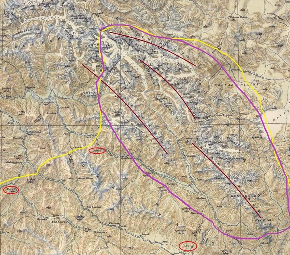
Now as for the main Karakorams it has a number of sub Ranges and out of these 3 lie fully on the Indian side and a 4th lies partly on the Indian side. The Sasser Muztagh is the southernmost sub Range of the main Range and lies between the bend of the Shyok when it changes direction and heads in a Northern direction. The Shyok rises in the Rimo Muztagh which lies above the Sasser Muztagh. The same trend is shown by the Nubra which also joins the Shyok and its at this point the Baltoro Sub Range starts which is partly on the Indian side. So the Sasser and the Baltoro Ranges are divided by the Nubra which rises in the Siachen Glacier. The Sasser La runs roughly between the Sasser Muztagh and the Rimo Muztagh. And in the extreme North along the Siachen Glacier runs the Siachen Muztagh.

And all these Sub Ranges further have different Groups of Peaks within them which Ill try and list below as given in the Royal Geographic Society Map of the Karakoram from 1939 as below :
Sasser Muztagh : Main Peak Groups
Shyok Group
Kunzang Group
Arganglas Group
Shukpa Kunchang Group
Chhusku Group
Sasser Group
Rimo Muztagh : Main Peak Groups
Rimo Group
North Terong Group
South Terong Group
Kumdan Group
Shelkar Group
Siachen Muztagh : Main Peak Groups
Teram Kangri Group
Teram Shahr Group
Singhi Group
Kyagar Group
Main Peaks (Out of the 20 Highest Peaks in India 12 Lie in the Karakorams)
Saltoro Kangri 7742
Sasser Kangri I 7672
Mamostong Kangri 7516
Sasser Kangri II 7513
Sasser Kangri III 7495
Teram Kangri I 7462
K12 7428
Ghent Kangri 7401
Rimo I 7385
Apsarasas Kangri I 7243
Rimo III 7233

Leaving you with a Classic Royal Geographic Map of the Karakorams in 1939 and a Map with some marked lines and places circled for reference. The Yellow Line is the LOC / Border while the Purple line is the extent of the Karakorams in India. (As in De Facto)
The Illustrated Mountain Geography of Ladakh
The Mountain Geography of Ladakh makes for interesting reading situated as it is between the Great Himalayan Range and the Karakoram Range. Also running within Ladakh are the Ladakh Range and the Zanskar Range but most people do not have a clear idea as to which Pass co-relates to which Pass.

The mighty Nun Peak of the Great Himalayan Range at 7135 m its the highest Himalayan Peak in Jammu ans Kashmir (not including the areas under occupation). On the side is the Saddle Peak.
The Illustrated Mountain Geography of Ladakh
Ladakh, the name comes from “ La Dvags” which means the Land of the High Passes. Most of us are well aware of the fact that it's a Trans Himalayan Desert. But there are other finer parts of the Geography which make it more interesting.
If you are driving to Leh whether from the Srinagar side or from the Manali side you have to cross the first major Range which falls in the way. These are the Pir Panjals. From the Srinagar side you cross it before coming into the Kashmir Valley through the Banihal Tunnel which was built under what used to be the Banihal Pass. You can also come from the Mughal Road and on that Road you cross the Pir Panjals at the Pir Ki Gali Pass. In case you are coming from the Manali side you cross the Pir Panjals at the famous Rohtang Pass. But the Rohtang Pass will soon meet the fate of the Banihal Pass as the Rohtang Tunnel is expected to be operational by the end of the Year. But it might survive as a Tourist attraction for people who want to see and experience Snow. Though the Passes on the Pir Panjals are not as high as some of the higher Passes further afield yet they are notorious as they get the maximum amount of precipitation in the Western Himalayas in the form of both Snow and Rain.

The transition between the Great Himalayan Range and the Zanskar Range as seen from a flight.
After crossing the Pir Panjal Range it's time to now cross the big Daddy. The Great Himalayan Range itself. From the Kashmir side you do it from the Zoji La and from the Lahaul side you do it via the Baralacha La. Both of these Passes are quite notorious and give a hard time to many though in recent years they have been tamed to some extent. There is talk of a Tunnel itself under the Zoji La but I guess that is many years away for now. After crossing the Great Himalayan Range from the Manali side after passing over a couple of passes you need to cross the Zanskar Range and this is does at the Tanglang La. While coming from the Kashmir side you cross the the Zanskar Range at Namika La and Fotu La.
And then if you want to go further North you have to go across the Ladakh Range which is crossed over at the famous Khardung La and now you come face to face with the most perpendicular of all the Mountain Ranges in the World. The Karakorams. Standing atop the Khardung La you can see the difference. The nicely rounded Peaks of the Zanskar and Ladakh Range in deep contrast to the craggy Towers of the Karakorams. Of course you can cross the Karakorams also (in a perfect world) over the Karakoram Pass but that's quite out of the question as of now.

A Truck astride the Great Himalayan Range as it approaches Zoji La.
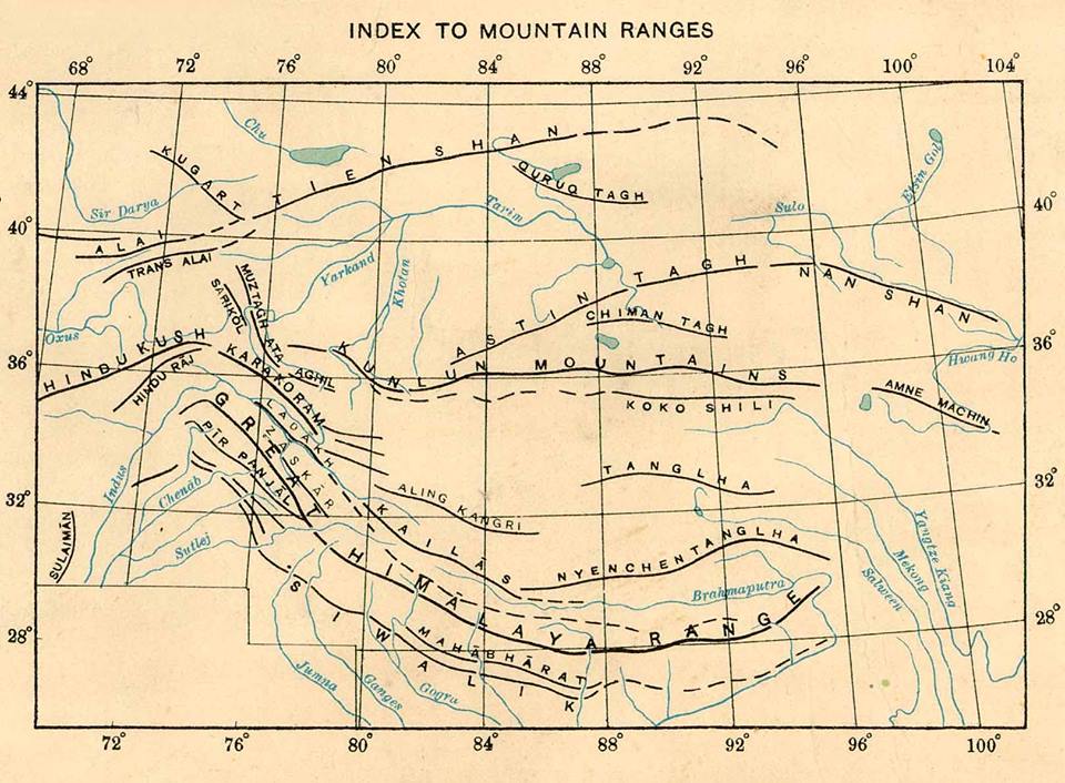
Traditionally the Indus has been considered the dividing line between the Karakorams and the Himalayas. The Ladakh Range is considered by some to be a part of the Karakorams. Even the Encyclopaedia Britannica says its a part of the Karakorams but a majority of researchers consider it a part of the Himalayas as the Ladakh Range (and its sub Range the Changthang Range) along with the Kailash Range and the Nyeng-Chin-Thanla Range run almost parallel to the Great Himalayan Range all the to its Eastern extremity and hence its considered a part of the Himalayas rather than the Karakorams.
Most people who visit the fact are usually oblivious to the fact that Ladakh is located within the Karakoram Range and the Great Himalayan Range. One marks the Northern Boundary the other makes up the Southern Boundary. And most actually miss seeing the Great Himalayan Range up close from the other side. We all usually see the Great Himalayan Range from this side ie the side which faces the Indian subcontinent but seldom do we see it from the other side and Ladakh gives the perfect opportunity to do the same. Infact this is the only Place where you could have Breakfast under the shadows of the Great Himalayan Range and have dinner in the shadow of the Karakoram Range (or one of its Muztaghs as its sub-Ranges are also called). But in order to view the spectacular Great Himalayan Range you have to come down to Kargil and head into the Suru Valley. Its here in the Suru Valley sandwiched between the Zanskar Range and the Great Himalayan Range is where you get spectacular view of the Great Himalayan Range with its craggy Peaks quite different from the ones of the Zanskar or the Ladakh Range. Ah to look at the Nun Kun Peaks from Panikhar is one of the most spectacular views in the Himalayan Region but most just miss it.

The Karakorams as seen from Khardung La.
And of course you get great views of the Karakorams from the Khardung La but the views from Nubra Valley and beyond are not so spectacular but there are areas in Ladakh from where you can get great views of the Karakorams but these areas are off limits due to reasons which do not need to be elucidated here. But hopefully they will be opened someday and the beauty of the Karakorams in all their vertical glory is revealed to all of us.
The pics below show some of the things mentioned above. The magnificent Nun Kun Peaks as seen from the Suru Valley, a pic from a Flight showing the transition from the Great Himalayan Range to the Zanskar Range, a Truck astride the Great Himalayan Range near Zoji La, a pic of the mighty Karakorams as seen from Khardung La and lastly a Map for guidance on the Himalayan Range.
Kiki’s Blog
Stories from the Himalayas








Five years ago the Galwan Valley was in the News for the wrong reasons after a deadly clash between the Indian and Chinese Armies in the Valley located in Ladakh lead to many deaths on the contentious Border between the two countries in wake of continued Chinese intrusions into Indian territory.
This area along the Shyok River, of which the Galwan Nallah or the Galwan River which forms the Galwan Valley has been off limits to Civilians since long but now the Indian Government has decided to open up the area for Civilians and we were amongst the First Civilians to venture into this beautifully desolate part of the Eastern Karakorams in Ladakh. Earlier Civilians could only venture upto the Village of Shyok from where the Shyok River takes a U turn and flows in a Northerly direction.