

Understanding the LoC in Kashmir
Most people are eternally confused about the location of the LoC in Kashmir. And Tourists are shown the LoC from almost everywhere. Even the Pahalgam side.
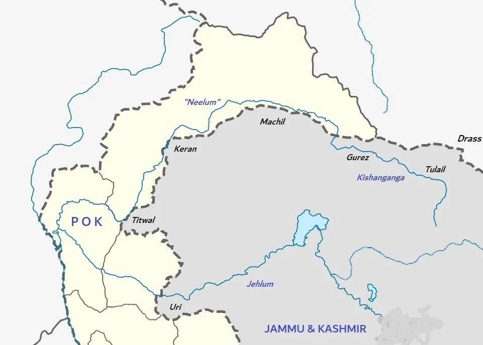
Anyways this is a simple Map which explains the LoC in Kashmir.
The Line of Control in Kashmir
Most people are eternally confused about the location of the LoC in Kashmir. And Tourists are shown the LoC from almost everywhere. Even the Pahalgam side.
Anyways this is a simple Map which explains the LoC in Kashmir. The LoC kind of plays around the Kishanganga aka Neelam. The Kishanganga originates in the "Great Lakes" Region of Kashmir specifically from the Kishansar Lake and comes down into the Tulail Valley and then onwards to Gurez and at Bagtore in Gurez is where it enters PoK or the LoC and becomes the Neelam. From there on both banks of the River run through PoK and has places like Taobat and Kel and of course the very beautiful Village of Arang Kel (Google Arang Kel). The Indian side pushes very close to the Neelam in Machil sector.
And then again India manages to take one side of the bank in Keran. And again the Kishanganga emerges. Further on again both sides are in PoK and it becomes the Neelam.
But again at Teethwal in the Karnah Valley the Indians managed to take one bank of the River. The Battle of Tithwal was an epic Battle and it was in this Battle that Piru Singh and Karam Singh won Param Vir Chakras.
But again after Teethwal the Kishanganga forever becomes th Neelam till it meets the Jehlum at Domail.
The Loc below this area lies around the Uri sector on what used to be the Jehlum Cart Road. Uri itself used to be connected to Poonch via the Haij Pir Pass but that was taken by the other side.
So this August we are doing an LoC drive where we will start from Uri and the road to Haji Pir and then onto Tithwal. Then Keran. The Machil. Then we would enter Gurez and go till Bagtore and then in the other direction all the way to Tulail and hopefully across the Kaobal Gali into Drass and then return to Srinagar.
Kiki’s Blog
Stories from the Himalayas








Five years ago the Galwan Valley was in the News for the wrong reasons after a deadly clash between the Indian and Chinese Armies in the Valley located in Ladakh lead to many deaths on the contentious Border between the two countries in wake of continued Chinese intrusions into Indian territory.
This area along the Shyok River, of which the Galwan Nallah or the Galwan River which forms the Galwan Valley has been off limits to Civilians since long but now the Indian Government has decided to open up the area for Civilians and we were amongst the First Civilians to venture into this beautifully desolate part of the Eastern Karakorams in Ladakh. Earlier Civilians could only venture upto the Village of Shyok from where the Shyok River takes a U turn and flows in a Northerly direction.