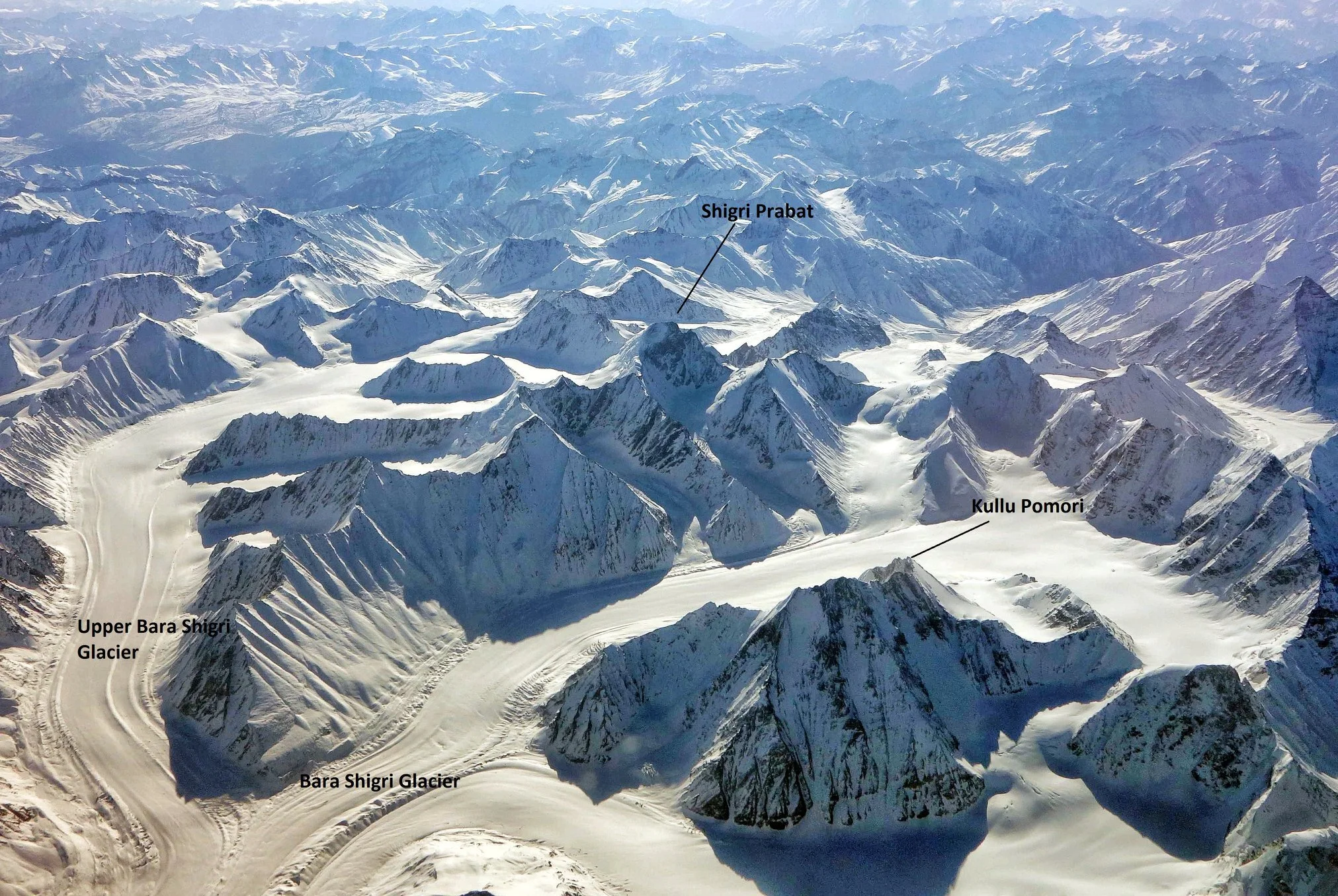
The Nun Barashigri Glacial Region
Glaciers and the current rate of degradation of Glaciers is a great Topic of Debate in the World. And of course here in the Himalayas we have a great concentration of Glaciers (do not confuse them with the Giant Glaciers of the Karakorams). We have Glaciers in the Western Himalayas as well as the Kumaon Himalayas with the Gangotri, Milam, Pindari etc being the well known ones. But unknown to most the largest concentration of Glaciers in the Indian Himalayas exists in a region known as the Nun Barashigri Glacier Zone. This is the inner sanctum of the Westen Himalayas with few people ever going anywhere near this Region.
As per the Glaciers of India by Vohra : “ Glaciers are found in all geographic areas of the Himalaya which lie above the elevation required to maintain ice. In some areas, they occur in large numbers and attain great lengths — measurable in tens of kilometers. Such mountain areas in India are the Nun-Barashigri, Gangotri-Chaukhamba, Kāmet group, Nanda Devi group, and Kānchenjunga. The principal glaciers of the Indian Himalaya, including their lengths, are: Gangotri, 30 km; Zemu (Sikkim Himalaya), 28 km; Mīlam (Nanda Devi area), 19 km; and Kedārnāth (Gangotri-Chaukhamba area), 14.5 km.”
This Inner Sanctum of the Nun Barashigri Glacial Region starts from the Region around the Nun Kun Peaks and continues South wards along the main spine of the Great Himalayan Range. The Nun Kun Peak lies between the Suru Valley in Ladakh and the Warwan Valley of Kishtwar. The Chenab is the main River into which most of the Rivers of this inner sanctum drain into though some Rivers drain into the Indus as well. Also it is very interesting to note that the Indus and the Chandra Bhaga / Chenab follow a parallel course on either side of the Great Himalayan Range. The Indus between the Zanskar and the Ladakh Range and the Chenab between the Pir Panjals and the Great Himalayas. Though Himalayan Region gets a lot of visitors few ever venture anywhere near this inner sanctum which is probably due to the fact that few people know of the existence of this vast Glacial belt. Over a 1000 Glaciers which feed mostly into the Chenab. The wild Nallahs which join the Chenab / Chandrabhaga are just a reminder of the wilderness that they originate at.
So why exactly is this area so unvisited ? Well for one the southern approach to this area is from the Kishtwar Region of Jammu and Kashmir. These are also known as the Kishtwar Himalayas and a favourite among foreifgn climbers who cant have enough of the Kishtwar Himalayas and their similarity to the perpendicularity of the Karakorams which is due to the fact that both have had great Glacial movements. Getting a glimpse of the Kishtwar Peaks still requires a few days of walking except when you see them from a flight. And Kishtwar sits in the shadow of Kashmir gets an amount of blow back though for many years the Region is comparatively trouble free. And of course the Roads are few and far between and not many people Trek in this Region. So thats another reason. And the most basic reason is that people just dont have a clue about this Region.
The Bara Shigri Glacier
As per the Glaciers of India by Vohra : “ The southern flank of the Nun-Barashigri range forms the northern portion of the Chenab River basin, north and east of Kishtwār; it is one of the most highly glacierized areas of the Indian Himalaya. Nearly 1,000 large and small glaciers drain into the Chenab River. The northern flank of the Nun-Barashigri range also supports many glaciers, which drain north into tributaries of the Indus River. Several glaciers are greater than 10 km in length; two exceed 20 km, and a third is a little less than 20 km. Several ice fields, drained by outlet glaciers, occur in the general area around Nunkun peak and also on the mountain itself. Ice fields are formed on mountain summits, or slightly lower down, and the highest summits protrude through the ice. This geomorphic characteristic is unique to this area, and perhaps indicates an earlier erosional surface. The glaciers are fed by both summer (monsoon) and winter (westerly) precipitation.
Presently, many cirques and small glacier valleys, especially in the eastern part of the range, are ice free, indicating a post-glacierization phase. Landsat 1 MSS images of the area (Path 158–Rows 37 and 38), acquired on 4 September 1972, show the transient snow line at its highest elevation of the year. Landsat 2 MSS images were acquired on 10 and 11 September 1976 (Path 158, and 159–Rows 36 and 37), following a fresh snowfall. This late monsoon snow covered the highest points of the main Himalaya Range, and was not restricted to a particular elevation as is sometimes thought to occur. Figure 3 shows a map of that area, prepared for the preliminary Inventory of Himalayan Glaciers (Kaul, 1999). Based on the preliminary inventory, it is estimated that there are 989 glaciers covering 2,280 km2 in the Chenab basin.”


